News — 18 June, 2024
The Impact of Collaborative Humanitarian Mapping on Disaster Preparedness in Ecuador
Collaborative humanitarian mapping enhances risk management in Latin America and the Caribbean, as demonstrated by the rapid response to the floods in Esmeraldas, Ecuador. Collaboration and open data were key to making informed and effective decisions.
English version / Versão em português
Natural disasters have always been a part of human history, and today, Latin America and the Caribbean are facing an increase in hurricanes and earthquakes due to the climate crisis and extreme weather events like El Niño and La Niña. These crises put lives and resources at risk, making effective risk management in the region crucial. However, this management is often hindered by a lack of updated and accurate geospatial resources. Despite these challenges, collaboration and the use of quality data from open mapping tools and collaborative databases like OpenStreetMap (OSM) can significantly enhance risk prevention and informed decision-making.
In June 2023, responding to alerts from the OSM community in Ecuador about severe floods in the Esmeraldas area, a dialogue was initiated with the Subsecretariat of Information Management and Risk Analysis of the Risk Management Secretariat. Over two years, there has been growing curiosity from authorities about the usability of collaborative data. Therefore, the initial mission was to establish dialogues and carry out pilot projects to demonstrate the usefulness of this information in disaster management.
The Risk Management Secretariat of Ecuador showed interest, and the collaborative mapping in Esmeraldas demonstrated the effectiveness of joint efforts. In a few weeks, the Latin American OSM community was mobilized to map the affected area, though some residual parts remained unmapped, which is common in such situations, especially in densely urban areas.
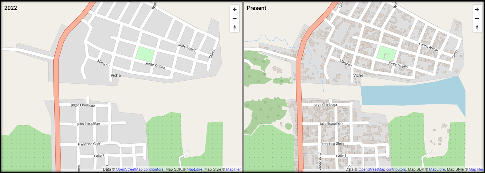
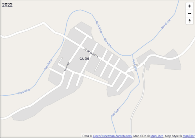 Image of Cube before/after Activation
In conversation with Iván Tercero of OpenLabEC, a citizen lab in Ecuador that seeks to generate dialogues and experiences on digital culture, citizen participation, and open knowledge, he shared that the activities in Ecuador fostered alliances and attracted people interested in humanitarian and social mapping.
At the 2023 Mapathon, the Secretariat invited relevant organizations to participate, and coordination was done with communities, working with YouthMappers and HOT to define activities. OpenLabEC supported field mapping related to volcanoes and worked intensively with YouthMappers to organize the in-person mapathon at the National Polytechnic School, with the Risk Management Secretariat as a key partner in the call.
Following the success of mapping in Esmeraldas, the Risk Management Secretariat identified an invaluable opportunity: to carry out a nationwide anticipatory mapping to anticipate and mitigate risks associated with the El Niño phenomenon in the second half of the same year 2023. With this goal in mind, the Secretariat led an extensive Risk Management Mapathon that lasted two months, from September to November, with a multisectoral call. Companies, organizations, and various ministries were invited to join in conducting workshops, generating data, and analyzing territorial initiatives.
In conversation with Virgilio Benavides Hilgert, former Subsecretary of Information Management and Risk Analysis at the Risk Management Secretariat of Ecuador during the period, he stated:
In Ecuador, we face the dilemma of what to do in case of a disaster. Although we have operational data from the Military Geographic Institute (IGM), the level of detail provided by OSM is even more relevant for us, who are responsible for ensuring safety in emergency situations. I consider it essential to have detailed information on that scale. That’s why I am interested in exploring how we can promote collaborative mapping in various places, beyond the academic sphere. Our focus is to identify institutions with strong planning and development management to facilitate this process.
The Mapathon was a massive collaboration that brought together various actors to address upcoming challenges. From the base established in Esmeraldas, mapping was extended to broad areas of the country, prioritized together with the Secretariat under a methodology generated among various actors, allowing for an efficient workflow during the activation.
Methodology
The Secretariat had its methodology to identify high-risk areas, which we sought to enrich with the support of students from the University of the Armed Forces (ESPE) and participants from the Youth Mappers GeoMap Espe chapter, who had worked on a multicriteria risk analysis related to the El Niño phenomenon. Together, we created a combined methodology that could adapt to different anticipatory mapping contexts, which the Hub would open for future activations.
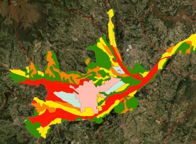
Image: Risk map of the urban area of Cuenca, generated from multicriteria evaluation, by Geomap ESPE
In summary, we followed four methods to delimit the areas to be mapped:
-
We identified unmapped rural areas showing continuous problems due to the El Niño phenomenon. This led to the creation of specific projects in Célica and Zosoranga.
-
The Ecuadorian authorities provided specific areas of high interest due to their potential risk. We used these areas to create projects in Latacunga, Quito, and Guayaquil.
-
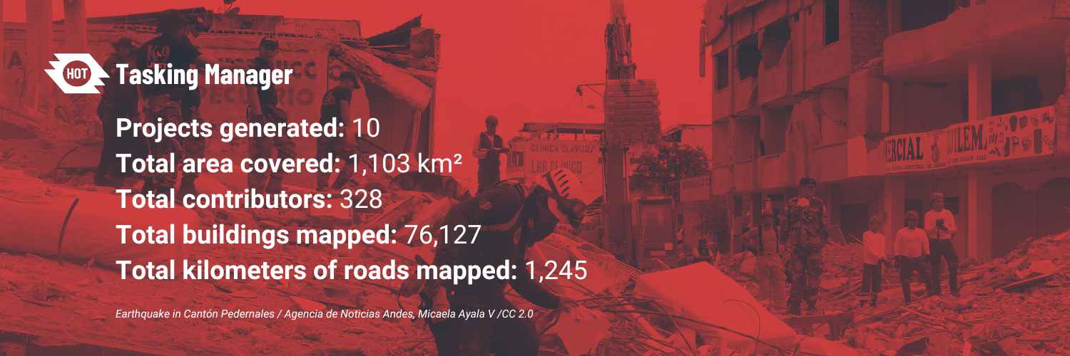
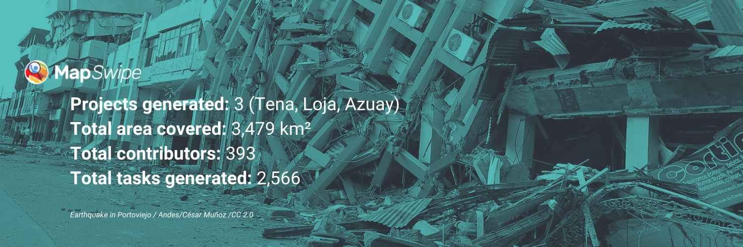
Some areas provided by the government were too general and extensive to be completed in the assigned time. We opted to generate preliminary projects for identifying roads and buildings in MapSwipe. Based on the results, we created OSM mapping projects in Tena, Loja, and Azuay.
-
Using the multicriteria evaluation methodology developed by the YouthMappers Geolab team, we identified two key areas in Guayaquil and Cuenca for mapping projects in the Tasking Manager. This methodology considers factors such as slopes, rainfall, distances to roads and rivers, and vegetation cover to determine areas at higher risk of flooding.
With the collaboration of ESPE and Geomap students, our team aimed to characterize and prioritize all areas of the country and conduct the base mapping of these areas before the end of 2023. During this process, we created a specific workflow for anticipatory activation based on three phases: preparation, activation, and response.
The preparation phase included identifying areas to be mapped, prioritizing them, and training volunteers for specific tasks in OSM, in repeated sessions aimed at various audiences and universities. The activation phase focused on mobilizing mappers, generating and monitoring projects in the Tasking Manager, and coordinating resources. Finally, the response phase involved delivering data to local authorities for use in emergency planning.
The experience was a demonstration of how collaboration between different actors can strengthen disaster response capacity. With a community-centered approach and the use of technologies like OSM, the resilience of communities to adverse events like El Niño can be improved. Ultimately, this project served as a model for future anticipatory mapping initiatives in the region and reinforced the importance of multisectoral collaboration in natural risk management.
Results
These data correspond to three towns, 42 villages, and 368 mapped population centers.
Virgilio highlights the importance of updating maps for decision-making in emergencies. He points out that zoning is done in the field by municipalities and firefighters, using these data for precise assessments. Although preventive mapping does not have an immediate impact, it is crucial for rescue tools such as the Initial Needs Assessment of the Risk Management Secretariat, which uses OpenStreetMap data. Timely map updates provide essential details of infrastructure and terrain, benefiting municipalities and the local population in identifying critical areas.
Next Steps
The LAC Hub seeks to strengthen and expand communities of young mappers and decision-makers. In the risk mapathon, students from GeoMap ESPE coordinated preventive mapping dynamics, receiving workshops and advanced training in OSM.
Geomap and other collaborators are long-term strategic allies for future projects such as mapping the Amazon and the Humanitarian Mapping Brigade, an initiative developed from this collaboration to strengthen local capacities and promote the culture of humanitarian mapping in the region.
With OpenLabEc, we are strengthening working groups and planning an annual mapathon with the Risk Secretariat, promoting the mapping of risk areas in Ecuador through Amazonian Mappings, training students in cities like Nueva Loja, Tena, Puyo, and Macas.
Iván from OpenLabEc highlights the importance of working with social organizations, Ecuadorian Decentralized Autonomous Governments (GADs), and universities in the Amazon. Students and teachers have constantly updated techniques and tools, positioning mapping as a relevant educational tool.
By mid-2024, the Risk Management Secretariat is preparing a national mapathon to address the La Niña phenomenon. The LAC Hub collaborates with the National Commission for Aerospace Research and Development (CONIDA), INDRA, and AmeriGEO in Peru for Earth observation, involving key organizations in a mapathon to assess territorial risks. Similar activities are planned for AmeriGEO Week 2024 in Quito.
Collaboration and the use of open mapping data like OSM are crucial for risk prevention and decision-making. Projects like the Risk Management Mapathon in Ecuador and Peru strengthen knowledge and capacities in the face of disasters, serving as a model for future initiatives.