News — 04 March, 2025
The [geospatial data] have and have-nots: 15 years of bridging the divide
As we celebrate the Humanitarian OpenStreetMap Team’s 15 anniversary, we reflect on the role of community-generated geospatial data in solving many of the core challenges we face this century. How can our wider data-centered international community bring in voices that are often left out?
Data is everywhere and can be used by everyone to improve their lives. Or so we assume. Yet, in our line of work, relevant geospatial data is often missing or inadequate to serve the needs of the people or institutions.
The divide
If you are reading this from a country or city with resources, the idea of lack of data might not be apparent to you. You are likely to have access to strong communications infrastructure, “big data,” and datasets collected by your own organization or the private sector. You are also likely to have access to human resources that could generate insights using the volumes of data in your reach. Even so, you may struggle to get the right data from time to time, at the right price, or with the necessary granularity. And you may struggle to turn insights from this data into action by decision-makers. Still, even if it is not perfect, you are on the side of the “data haves.”
At the Humanitarian OpenStreetMap Team (HOT), we work in places at the other end of the spectrum, the side of the “geospatial data have-nots.” Our journey as an organization began in Haiti, where we provided geospatial data to humanitarian organizations in desperate need of it when responding to the 2010 earthquake. We now work with governments, civil society organizations, and small businesses in low- and middle-income countries (LMICS), which struggle to get that type of data and use it. There are several reasons for this struggle, but the most obvious one is the lack of access to technical resources and capacity. But there is a relatively simple solution.
The bridge
Our approach is based on the power of open geospatial data and the role local people play in becoming “data-have” communities and countries. Most of our work is based on the OpenStreetMap (OSM) platform, created more than 20 years ago by volunteers around the world to have a free, editable, and useful map of the world. It is widely used by corporate organizations, government agencies, and regular people, and in many parts of the world, it is the most reliable geospatial data platform. Using OSM, we engage communities, volunteers, governments, and civil society organizations around key challenges and use the data to understand the problem and identify solutions. But in order to do this, they need the right tools and skills.
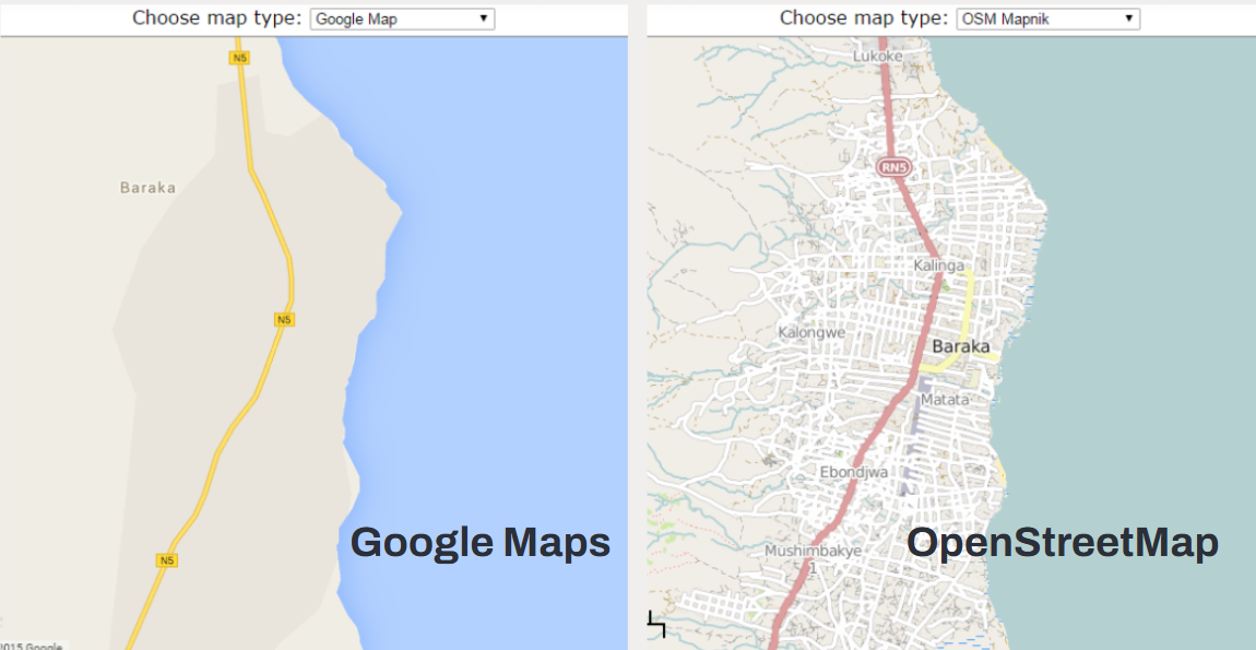 Image: Side-by-side comparison of the same area surrounding Baraka city, Democratic Republic of the Congo (DRC), as shown in Google Maps vs OpenStreetMap. Source: Map Compare by Geofrabrik.
For example, open-source tools are essential to democratize access to geospatial information. At HOT, we have identified key gaps in open mapping technologies and developed new tools accordingly. Our flagship tool, the HOT Tasking Manager, allows digital volunteers to collect extensive amounts of geospatial information in an efficient and effective way, particularly during disasters and humanitarian responses. Additionally, we develop tools that cover other crucial steps of collecting, downloading, and analyzing open geospatial data, centering the people who need it in the tools’ design. For example, gathering more granular information requires purposefully crafted surveys collected through inexpensive tools, which is why we are spearheading a product called the Field Mapping Tasking Manager. In Dominica and St. Lucia, we tested our Drone Tasking Manager, which aims to make drone data collection more accessible to governments and local groups. Finally, our AI tool fAIr has workflows that include localized validation of AI models, which lead to higher quality geodata at larger scales.
But data and tools can only go so far. It is the use and engagement with community members that matters. To foster and democratize geospatial data collection and use, it is essential to build skills among different kinds of users. At HOT, we find that people can pick up mapping skills quite easily with adequate training. Flying a drone, adding features or information to a geospatial database on a smartphone, and even analyzing data have been done successfully by women’s groups, youth groups, those in very remote communities, and more. HOT provides basic training and hands-on guidance to individuals and communities, as well as more in-depth training & support to governments and partners. The skills needed to create useful geospatial data are attainable, and the potential end results themselves, like thematic maps, engage people in a way that other forms of data visualization can’t do.
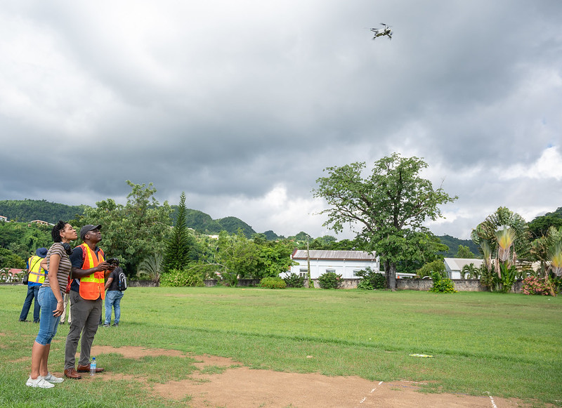
The Caribbean Drone Task Manager Training, led by Jamaica Flying Labs and funded by GFDRR, enhanced local expertise in drone mapping and geospatial data processing in Dominica and St. Lucia during September and October 2024. Participants gained advanced skills in drone technology, photogrammetry, and the use of Drone Task Manager software, completing real-world missions to produce geospatial products like orthomosaics and 3D models.
A Collaborative Effort
As communities map and collect geospatial data about the world around them, they also become active and aware of the challenges we collectively face at a local, national, or global level. Because once you look at a map, it is impossible to ignore our shared challenges like deforestation, flooding risks, or excluded populations. High-quality data and information can bring people together around a common problem and can facilitate finding a common solution.
The current gap between geospatial data haves and have-nots no longer needs to exist in this day and age, in large part because of collective efforts from people all over the globe. The work HOT has done in the past 15 years is a testament to the steadfastness of those individuals & groups -volunteer mappers, local communities, open tech enthusiasts, multilateral organizations, and more - to bridge this gap. We all envision a global map that represents people’s true reality and is accessible to everyone - a digital public good - no matter the challenge you face or where you come from. And when we are successful in addressing this gap, we can collectively make better-informed decisions that will improve conditions for everyone, no matter if you started as a data have or a have-not.