News — 25 January, 2025
Routes for Development: Mapping Roads for Connectivity and Development in Guatemala
Discover how the mapathon led by HOT and UNDP is transforming road infrastructure in Guatemala. Routes for Development now has precise data on rural roads, enhancing connectivity and territorial development. Learn about the impact of citizen science on public planning.
In an unprecedented effort to improve road infrastructure planning in Guatemala, the United Nations Development Programme (UNDP) and the Open Mapping Hub for Latin America and the Caribbean from the Humanitarian OpenStreetMap Team (HOT) joined forces to conduct a national mapathon. This initiative transformed the country’s rural cartography at a critical political moment. The collaboration aimed to fill a historical gap in geospatial information, allowing the government to integrate reliable data into the Routes for Development Program and other territorial development projects that would benefit from an updated national road map.
The Cartographic Gap in Latin America
In most Latin American countries and other developing regions, governmental cartography is inadequate, with outdated and imprecise data. This limitation affects decision-making, territorial planning, and crisis prevention. National geography institutes often have partial information that does not meet the needs of priority programs, while maps produced by consultants or private companies tend to be expensive and limited in scope. As a result, the creation of cartographic data is fragmented and dependent on future decisions, perpetuating the lack of a solid foundation for public policy.
In response to this deficiency, citizen science has proven to be a viable solution. HOT specializes in promoting the collaborative improvement of OpenStreetMap by mobilizing communities to generate open and accessible data. Although these maps do not always meet the official standards of national institutes, they have proven invaluable in decision-making at both municipal and national levels in various critical situations.
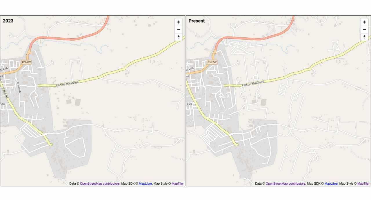
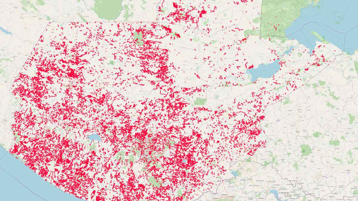
Image: Comparison of before and after mapping in Santa Cruz Verapaz, showing the transformation and update of local cartography.
Routes for Development: A Path to Connectivity
The Routes for Development program, promoted by President Bernardo Arévalo’s government, seeks to close the gap of economic and social exclusion in Guatemala by facilitating connectivity between rural and peri-urban communities and development centers. Historically, the lack of detailed information about rural roads and community locations has hindered investments in road infrastructure, limiting access to essential services such as healthcare, education, and economic development.
Before this initiative, the national road network lacked a significant number of local roads and rural trails, preventing their consideration in infrastructure planning. As Juan Carlos Méndez, director of the Routes for Development program, stated: *“There was such a large gap that unregistered roads simply did not exist in terms of public planning. Without precise data, we couldn’t connect rural Guatemala with urban Guatemala, perpetuating social and economic exclusion.” *With the data generated by the Mapathon, it is now possible to identify marginalized regions more clearly, understand existing connectivity means, and allow for more effective planning.
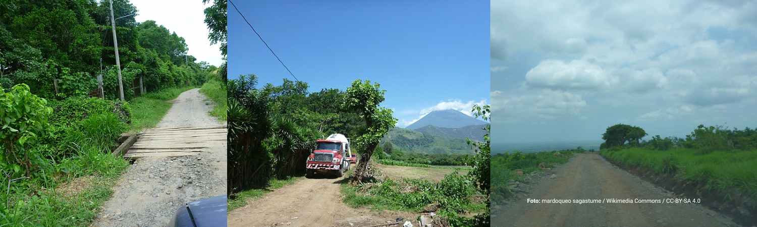
Image: Visualization of three roads in Guatemala.
The Activation: Citizen Science and Regional Volunteering
To bridge this data gap, the Humanitarian OpenStreetMap Team (HOT) and the United Nations Development Programme (UNDP) launched a massive mapping campaign, calling on volunteers through the UN Volunteers platform and direct invitations to local universities, including multiple campuses of Universidad de San Carlos and Universidad Rafael Landívar in the country, particularly in the prioritized department of Alta Verapaz. What began as a pilot project in Cobán, Alta Verapaz, evolved into a national initiative, surpassing all expectations for participation from the mapping community.
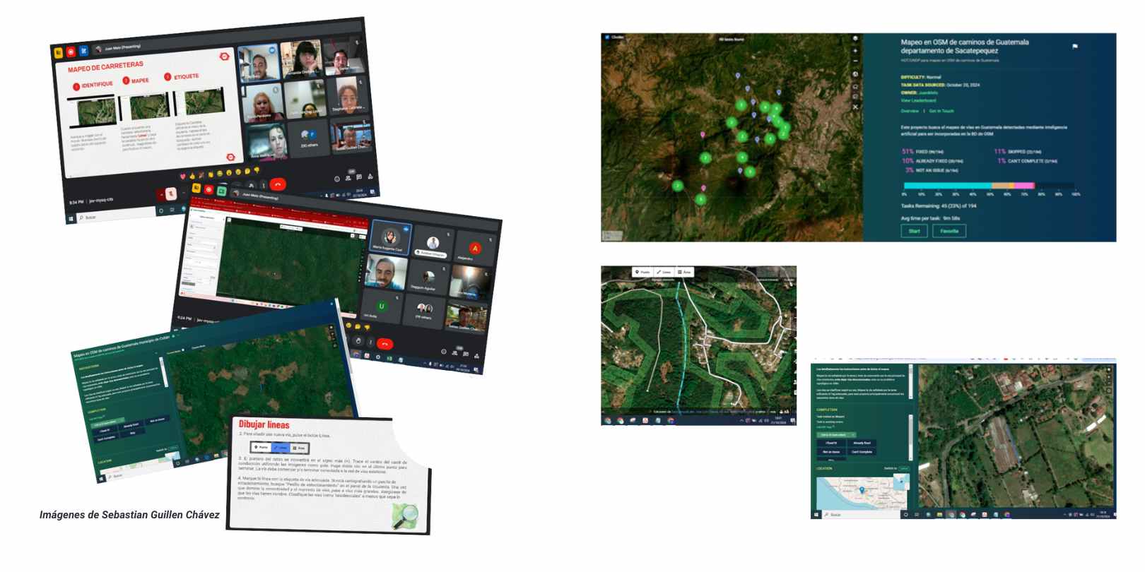
Image: Training and mapping in MapRoulette as part of participant Sebastián Guillén Chávez’s report.
Methodology and Follow-up
-
Call for Volunteers: Registration was opened on UN Volunteers, and direct outreach was made to academic and community networks, including new chapters of the Youth Mappers network created this year and previous ones.
-
Training: Volunteers participated in mandatory sessions to learn about road mapping using OpenStreetMap and specialized tools like MapRoulette.
-
Autonomous Mapping: Over a month, the HOT team supervised the process, answering questions and ensuring mapping quality.
-
Validation: Expert validators were hired, funded by HOT and UNDP, with sponsorship from TomTom and Kaart, to guarantee data accuracy.
-
Data Delivery: The data was released on OpenStreetMap and in downloadable formats like Shapefile, facilitating its immediate use by the government, NGOs, and other entities.
Osvaldo Salazar, a graduate of the Humanitarian Mapping Lab, actively participated in the training sessions and the subsequent online mapping, earning a certificate from UN Volunteers. Reflecting on his experience, he shares: “I am motivated to participate because I know that the information we generate can be of great help to someone. Learning to map has been an enriching experience, especially improving my road mapping skills thanks to the valuable advice received during the training sessions.”
Impact in Numbers
The results of the activation were impressive:
-
332 volunteers participated actively.
-
50,000 mapped roads, totaling 29,000 kilometers.
-
17,018 km of rural trails identified, crucial for mobility in remote areas.
-
12,421 km of main roads (residential: 5,709; minor highways: 5,551; service roads: 1,161).
-
Data used to prioritize infrastructure investments in Huehuetenango, Quiché, and Verapaces.
According to Juan Carlos: “Initial mapping estimates were 12,000 km, which we now know was far below reality. However, the Mapathon exceeded all expectations, covering much larger areas and providing essential data for planning.”
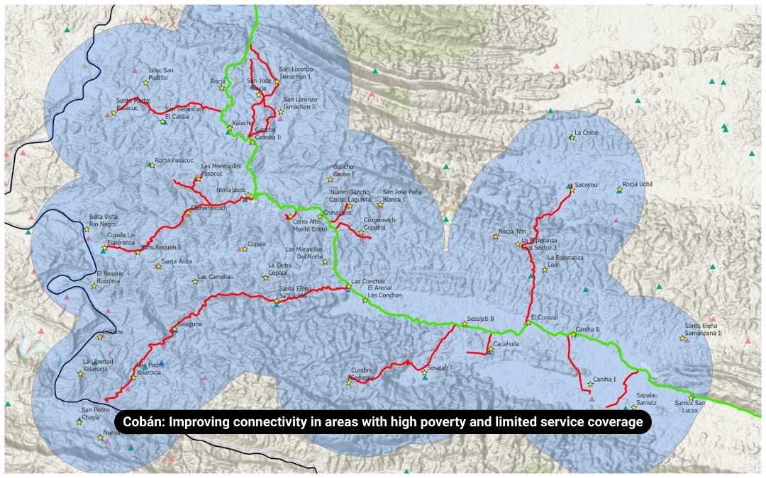
Image: The mapping of existing roads and their conditions in OpenStreetMap, combined with official data layers, allows for the precise identification of major infrastructure gaps that limit communities’ access to essential services. This information enables simple yet critical analyses to design connectivity corridors and optimize public investment.
Mapping as a Political and Planning Tool
The impact of this effort is not only reflected in the numbers but also in government decision-making. Thanks to the generated data, the government was able to identify and prioritize the most excluded areas of the country, where lack of connectivity disproportionately affects Indigenous populations. The information was presented to the president and his cabinet, facilitating evidence-based planning.
Carlos Duarte, director of Geotecnológica de Centroamérica and an expert in territorial development, emphasized: “The data arrived at a crucial moment when Guatemala’s road infrastructure institutions were facing a crisis. This allowed for planning alternatives that mark a change in how road infrastructure is developed and managed. Moreover, this effort is a powerful demonstration of the impact of citizen science.”
The Routes for Development program, the new presidential initiative focused on improving road infrastructure in rural areas of Guatemala, has found in the cartographic data of mapped roads—collected with HOT’s support—a key tool for decision-making. These data are not only being used to prioritize investments but also to plan construction projects, allowing for the creation of project profiles that estimate the number of kilometers to be improved and the beneficiary communities, with special attention to those with the least access to services.
With support from Universidad Rafael Landívar’s Territory and Climate Observatory, interventions for rehabilitating over 1,000 km of rural roads in three priority regions have already been approved, significantly improving connectivity and development in vulnerable communities by the end of 2025.
Lessons Learned
This Mapathon provided key lessons on the power of digital volunteering and citizen science:
-
Massive call-outs can exceed expectations and generate valuable inputs in record time, but they require meticulous management strategies to ensure data quality.
-
Using open platforms like OpenStreetMap democratizes access to information, enabling more inclusive and efficient planning at multiple levels.
-
While officializing the data remains a challenge, its immediate usefulness makes it an essential resource for strategic decision-making.
Juan Carlos explains that “the Routes for Development program coordinates efforts between ministries to connect the most excluded areas of the country. The dissemination of the map will be key to improving planning and addressing the needs of these communities.”
What’s Next?
The journey does not end here. HOT and UNDP call on governments, universities, and organizations to:
-
Continue with the detailed validation of mapping across Guatemala’s national territory. So far, data quality has been ensured in priority departments due to the urgency of the situation. It is essential to gradually extend this effort to the rest of the country, involving all sectors. Institutions, businesses, and communities are invited to contribute through mapping and sponsoring advanced mappers to strengthen this process.
-
Use this data for rural infrastructure planning and other programs, whether directly related to territorial development or not, understanding that progress happens gradually when there is a solid foundation for planning.
-
Replicate this methodology in other countries or regions facing similar challenges and cartographic gaps, adapting it to their specific contexts to improve territorial planning.
-
Continue strengthening the mapping community in Guatemala to ensure continuous data updates. We encourage those who participated in this initiative to maintain their commitment and, in many cases, their enthusiasm for mapping. We also invite them to share this interest within their communities—whether at their school, university, institution, or professional networks—and to join forums and community chats of OpenStreetMap Guatemala and Latin America.
The lack of cartographic information is not an insurmountable obstacle to evidence-based decision-making. We encourage all stakeholders to explore participatory alternatives, study successful cases of citizen science, and engage with those who have experience in the field (HOT, local communities, student networks, allied organizations, etc.).
Guatemala’s case demonstrates that access to precise geospatial information is not a matter of fate but a challenge that can be overcome in a short time through the strategic mobilization of digital communities and the use of open technologies. Every road mapped in OpenStreetMap is another step toward territorial equity and inclusive development.
Each cartographic need has an appropriate approach from which to assess challenges and opportunities. Identifying these challenges helps define more effective methodologies and conduct small-scale experiments. Even a minimal exercise can generate valuable insights within a decision-making team, while a broader one enriches information with the diversity of perspectives contributed by the community.