News — 14 March, 2025
Humanitarian Mapping in Bahía Blanca: Collaboration in Response to the Emergency
Swift and effective response after the floods in Bahía Blanca, Argentina. The LAC Hub mobilized the humanitarian mapping community to generate key data for response and recovery efforts.
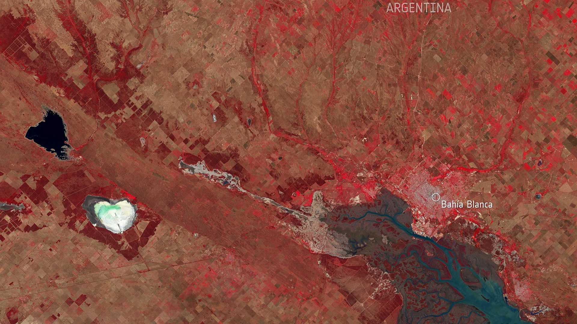
The humanitarian mapping response in Bahía Blanca was a clear example of the power of collaboration between local governments, communities, and global actors to respond effectively to a crisis. In March 2025, a series of heavy rains affected various areas in the south of Buenos Aires Province, causing floods that severely damaged homes, infrastructure, and essential services. While multiple towns were impacted, the city of Bahía Blanca established direct coordination with local government officials, who expressed a concrete need for mapping support. In response, the Latin America and Caribbean Open Mapping Hub (LAC Hub) activated an open mapping effort to generate accurate and updated geospatial data, supporting humanitarian aid and reconstruction work.
Bahía Blanca, a strategic port city in southern Buenos Aires Province, has a population of over 300,000 people. In early March, intense rainfall caused several waterways to overflow, affecting both urban and rural areas. The consequences included material damage, displaced people, and interruptions to basic services like electricity, water, and transportation.
In response to the emergency, HOT engaged with the city government to assess data needs, which led to a prioritization of specific urban areas—especially those that had experienced recent construction changes and were affected by the flooding. On March 11, the humanitarian mapping response was officially launched in coordination with the LAC Hub.
Initial Diagnosis and Activation
The Bahía Blanca city government’s request was clear: to obtain the best available data to effectively coordinate damage assessments and decision-making. As Fabrizio Scrollini, Regional Director of the LAC Hub, explains:
“The collaboration with Bahía Blanca came at the request of the local government and its advisors, seeking the best available information for disaster mapping activities. It was a concrete ask. In response, we activated the community and the brigade to provide the initial information authorities needed.”
The activation involved the participation of the LAC Hub’s Humanitarian Mapping Brigade and the voluntary support of the company Kaart, who worked remotely to map and validate buildings and infrastructure in the affected zones.
\
Map: Shows the mapped area.
Scope and Results
In total, four mapping projects were launched using the Tasking Manager. The results were significant:
-
Mappers: 73
-
Validators: 20
-
Buildings mapped: 45,837
-
Roads covered: 34 km²
The mapping and validation process reached 100% completion in just 15 days, enabling the delivery of accurate and useful data to local authorities in record time.
The local government team had recently taken office, so an updated base map was a valuable resource for early-stage planning and development. Manuel Aristarán, honorary advisor to the Municipality of Bahía Blanca, noted:
“We are very grateful for the activation; the data has been extremely useful for our early response actions, and also for future city planning.”
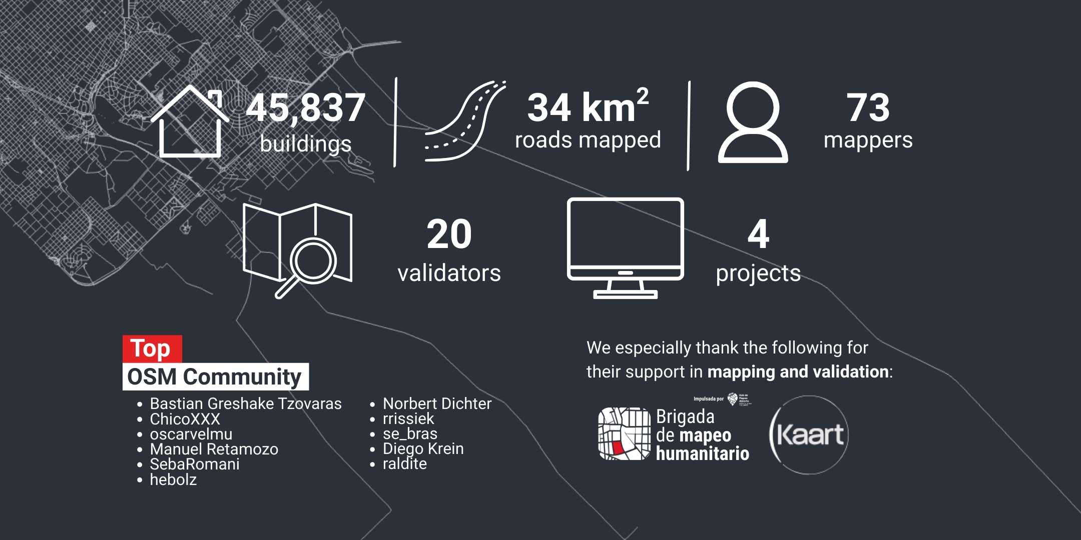
Image: Results from the activation — 45,837 buildings, 34 km² of roads, 73 mappers, 20 validators, and 4 projects.
Beyond the Emergency: Urban Planning and New Partnerships
Although the activation focused on responding to an emergency, the data generated now holds strategic value for the city. The new municipal administration has expressed interest in using OpenStreetMap not only for disaster management, but also for cadastral development, urban planning, and territorial management.
“Yes, we now have a new administration, with a lot of work ahead in cadastre and urban planning. The planning department has a more progressive view on data usage and is open to using more open data sources, including OSM,” said Manuel Aristarán.
New possibilities are also being explored, such as the use of drone-captured imagery to support long-term recovery and planning.
While Argentina has not historically been a priority country for HOT, we recognize that there are specific contexts in which we can add value. Argentina is a country with strong internal capacity, but in immediate emergency situations—like the one in Bahía Blanca—we can collaborate strategically to strengthen the response.
This type of activation is carefully evaluated, taking into account both the need and the potential for long-term impact and sustainability, especially in the context of restructuring and strengthening emergency services and risk management frameworks.