News — 26 March, 2025
Can low-cost drones contribute to mangrove monitoring and conservation? Testing Drone Tasking Manager in La Paz, Mexico
Drone Tasking Manager (DroneTM) is a digital public good that enables communities to generate high-quality, high resolution aerial imagery using low-cost drones. Discover its potential for community-driven mapping and its use in protecting mangroves in La Paz, Baja California Sur, Mexico.
Revolutionizing Cartography with a Digital Public Good
Access to aerial imagery has traditionally been limited to commercial satellites, conventional aircraft, or high-cost drones. This has excluded many communities and organizations from using these tools for disaster management, environmental conservation, and urban planning.
To change this, Drone Tasking Manager (DroneTM) has been developed as an open-source platform and digital public good that allows anyone with a drone, even a low-cost one, to contribute high-quality, high-resolution aerial imagery to an open and accessible repository. Instead of just reaching feature parity with conventional sources, the quality and detail exceed typical commercial imagery sources.
Ivan Gayton, Product Innovation Manager and Humanitarian Advisor at HOT, emphasizes the shift in accessibility by noting that “previously, aerial imagery was something only large organizations could collect; today, communities can generate their own aerial data with inexpensive, safe, lightweight (therefore lightly-regulated) and accessible drones.”
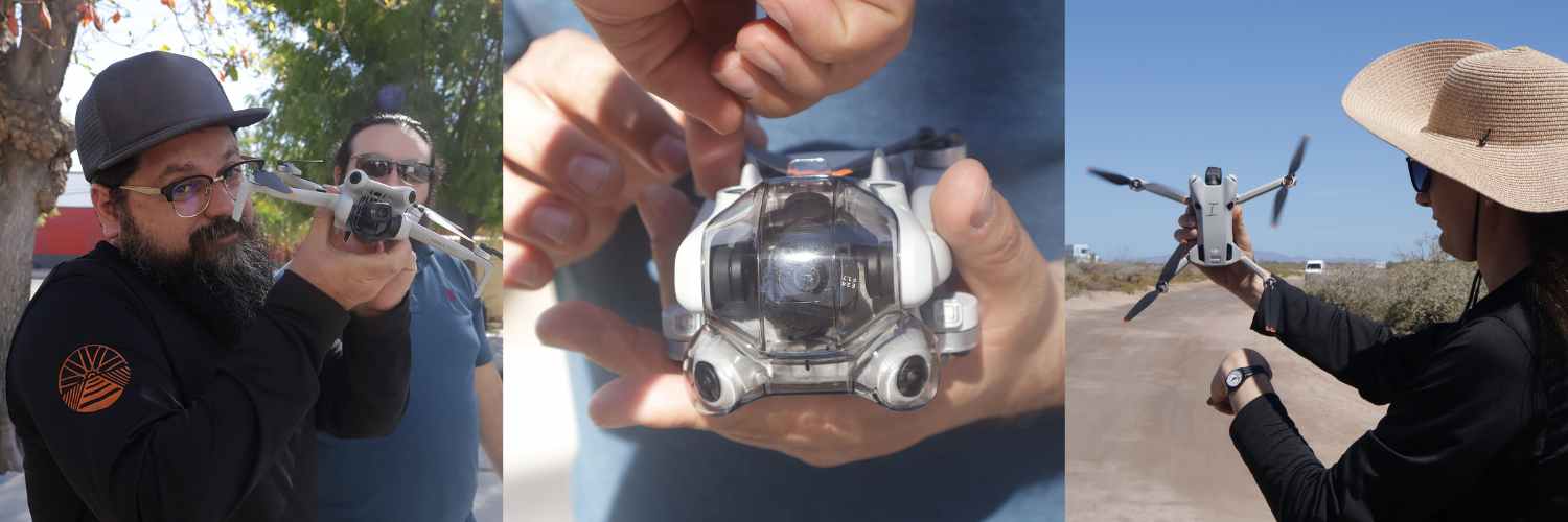 Image: From left to right — BSCicletos presenting the drone that will support the Guardianas del Conchalito, the workshop coordinator demonstrating the DJI Mini 2 drone, and finally, LAC Hub’s senior manager operating the drone. Credits: RollitoDeGuayaba / Wikimedia Commons, CC BY 4.0
What is Drone TM and How Does It Work?
DroneTM is an intuitive application suite designed to facilitate collaborative aerial imagery collection. Its key features include:
-
Use of Low-Cost lightweight Drones: Democratizes access to aerial imagery by allowing the use of consumer and DIY drones.
-
Coordinated Efforts: Enables multiple operators to collaborate in covering large areas.
-
Fully automated imagery processing powered by OpenDroneMap to generate a 3D model, aerial imagery, and detailed elevation models.
-
Integration with AI and Field Mapping Tools: Provides essential inputs for analysis algorithms and mapping applications.
-
A Digital Public Good: Ensures that communities have access to open, high-quality geospatial data without dependency on expensive proprietary solutions.
Along with our partner, NAXA, the Humanitarian OpenStreetMap Team (HOT) has been performing field testing and iterative deployments in diverse regions such as Indonesia, Nepal, Dominica and St. Lucia, as documented by NAXA’s geospatial software developer Niraj Adhikari. Now, for the first time, we have tested its potential to support another frontier of community development: mangrove monitoring and conservation.
First Use Case: Mangrove Monitoring and Protection in La Paz, Baja California Sur
Adriana, a member of Guardianas del Conchalito, describes the breadth of their work: “In approximately 14 hectares of mangroves, we carry out surveillance, monitoring, shell collection… hydrological channels, we have a tree nursery, we collaborate with BSCicletos, CONANP, Costa Salvaje.”
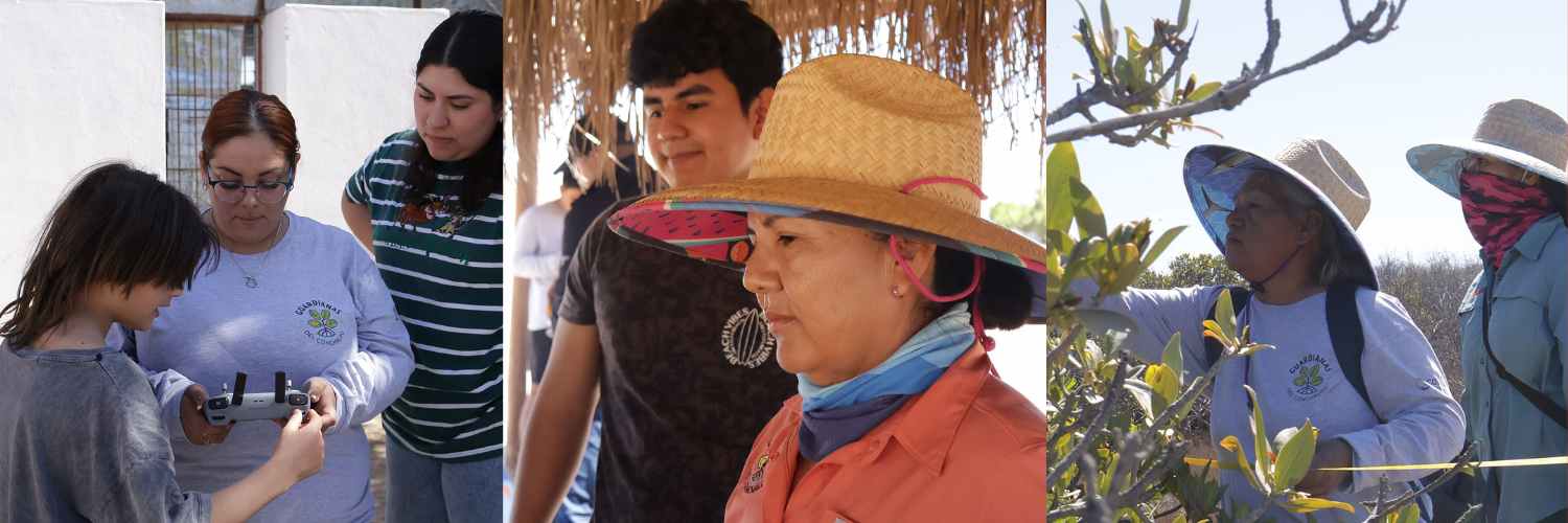 Image: From left to right — Guardianas del Conchalito learning how to fly a drone, the coordinator reviewing an orthophoto, and finally, the Guardianas conducting monitoring activities in the Mogote mangrove. Credits: RollitoDeGuayaba / Wikimedia Commons, CC BY 4.0
In February 2025, HOT implemented a DroneTM testing project in La Paz, Baja California Sur, in collaboration with the local organizations BCSicletos and Las Guardianas del Conchalito, to monitor and conserve the region’s mangroves. These ecosystems are crucial for biodiversity and coastal protection, as well as for locals’ self-sufficiency, as they are home to numerous animals targeted for fishing. However, they also face increasing threats such as uncontrolled urbanization and pollution.
Within this project, members of these two organizations, who are also residents of the area as well as the local fishing community:
-
Learned to operate drones and collect data using DroneTM.
-
Captured high-resolution aerial imagery from the most vulnerable mangroves, such as Manglar El Conchalito, to start analyzing the mangrove area.
-
Generated a 3D view of the mangroves and the surrounding landscape using OpenDroneMap.
-
Started creating an open imagery repository in OpenAerialMap and Wikimedia Commons to support monitoring, protection, and conservation initiatives.
 Image: Screenshot of the DroneTM website, a platform used for participatory drone mapping and visualization.
As monitoring continues, local partners can use DroneTM and its imagery to periodically record key variables like mangrove cover and extent, density and height, vegetation indices, mangrove fragmentation and connectivity, land use change, other degradation processes, mortality and regeneration cycles, etc.
Stephen Mather, Creator of OpenDroneMap, supported the La Paz project onsite and highlights how tools like ODM are changing who gets to create and use geospatial data.
“Access to creating base-level data, like what communities are producing with low-cost drones and OpenDroneMap, is something that 5 or 10 years ago only high-income states could manage. Now, it can be done locally, at low cost and with high value”, he shares.
ODM’s open-source design ensures that communities own and process their data locally, a critical aspect for groups monitoring sensitive areas like mangroves or documenting environmental threats.
“Too often, tech democratization is just a temporary effect funded by venture capital—available at low or no cost only until market capture. With OpenDroneMap, the tools and knowledge are Libre and built to last, enabling true participation and mutual support in community-led mapping”, Stephen highlights.
As this model grows, Stephen believes the next challenge is scaling through community networks, ensuring training and adoption can spread laterally across regions.
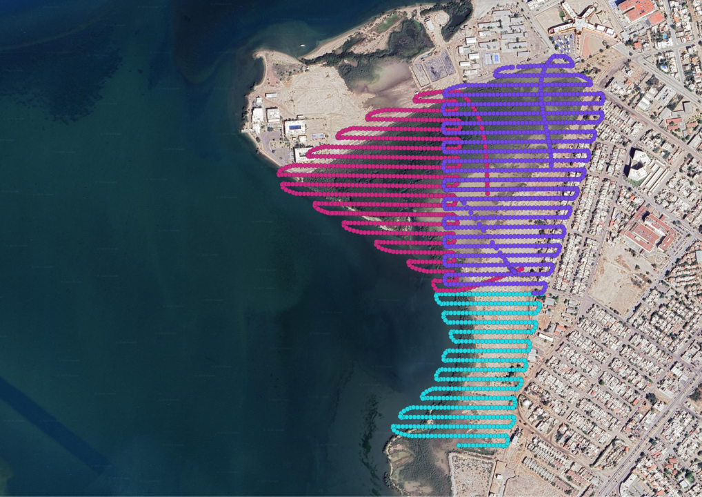
Visualization: Orthophoto generated from drone flights in La Paz, processed with DroneTM, and uploaded to OpenAerialMap for public and open access.
You can download the orthophotos generated by the drone flights directly from OpenAerialMap.
Towards a Network of Community Drone Operators
This project in La Paz is just the beginning of a broader vision, creating a network of community drone operators trained in using DroneTM. This would allow:
-
Generating additional and more frequent aerial imagery for emergency and disaster response by local communities themselves.
-
Creating detailed maps for community-centered land management.
-
Strengthening environmental advocacy and conservation efforts.
Beyond mangroves: Expanding the use of DroneTM in Community Projects
DroneTM has the potential to support a variety of community-led initiatives worldwide. Some examples include:
-
Disaster Response: Capturing real-time aerial imagery after hurricanes, floods, or earthquakes to support emergency relief efforts.
-
Urban Planning: Assisting informal settlements in mapping their neighborhoods for improved infrastructure and services.
-
Land Rights Advocacy: Supporting Indigenous and rural communities to document land use and protect their territories.
-
Environmental Monitoring: Tracking plant community composition, biomass, deforestation, coastline erosion, and biodiversity loss in protected areas.
Céline Jacquin, Latin America Senior Manager at HOT, highlights a key challenge in territorial studies: “Access to aerial imagery remains a fundamental limitation for most territorial studies today, and it becomes even more critical in emergencies or when the area of interest is not a priority for economic, political, or technical leaders of territorial development. This is often the case for rural communities and most Indigenous communities in the region. Democratizing the use of drones and the processing required for their application in cartography was an outstanding need—this represents a major innovation.”
In summary
This technology is transforming the way communities generate and use geospatial data. By making the technology to generate high-resolution aerial imagery a digital public good, we are enabling more people to make informed decisions, have the tools to participate in public policy, advocate for their rights, and build resilient communities. Moreover, DroneTM is also available for professionals, organizations, and governments interested in enhancing participatory mapping and environmental management.
Ready to join us? Here’s how you can get involved
-
Test DroneTM in your mapping projects.
-
Contribute to development via our GitHub repository.
-
Learn more about our field testing and deployment experiences, here and here.
-
For a deep dive into the training and practice activity given to grassroots organizations in La Paz, Mexico, please visit this publication.