News — 10 January, 2025
Anticipatory Annual Mapathons: Innovation and Collaboration to Close Mapping Gaps in Latin America and the Caribbean
The Annual National Anticipatory Mapathons (MANA) are an innovative strategy to close mapping gaps in Latin America and the Caribbean, strengthening risk prevention and management. In 2024, MANA made an impact in Ecuador, Peru, Colombia, and Guatemala, showcasing the power of open mapping to build more resilient communities.
Anticipatory Annual National Mapathons (MANA)
The National Anticipatory Annual Mapathons (MANA) have become a valuable tool to address critical mapping gaps in Latin America and the Caribbean (LAC). Driven by the LAC Open Mapping Hub of the Humanitarian OpenStreetMap Team (HOT), these mapathons respond to the urgent need for accurate geospatial data for risk prevention and mitigation. By integrating broad citizen participation within a limited timeframe, the use of open technologies, and multisectoral collaboration, the MANA initiatives provide valuable inputs for territorial planning and improve disaster response capacity.
OpenStreetMap (OSM), a global collaborative platform, serves as the backbone of this initiative. With an active community of 10 million registered users across more than 50 countries, OSM has demonstrated its impact by providing editable and accessible maps that support informed decision-making during crises, disasters, and preparedness efforts. The MANA initiative harnesses this technological infrastructure to generate up-to-date, high-precision data on territories and their risks, focusing on vulnerable areas identified and prioritized by national authorities and experts. These mapathons mobilize mappers, primarily locals, along with the broader regional community. As the saying goes: “No one maps better than those who know and embody their own territory.”
The strategy behind these mapathons aims to rapidly close cartographic gaps in key areas, such as disaster management, while also highlighting initiatives led by national institutions in each country and regional organizations. The goal is to build a knowledge community and strengthen practical learning in citizen science. The LAC Hub of HOT acts as a technical partner, overseeing community mobilization strategies, the creation of projects in the Tasking Manager, the delivery of basic mapping training sessions, and the organization of data validation processes.
In 2024, the MANA demonstrated its transformative potential, with successful implementations in Ecuador, Peru, Colombia, and Guatemala, leading to data-driven decision-making.
First and Second Annual National Mapathon in Ecuador
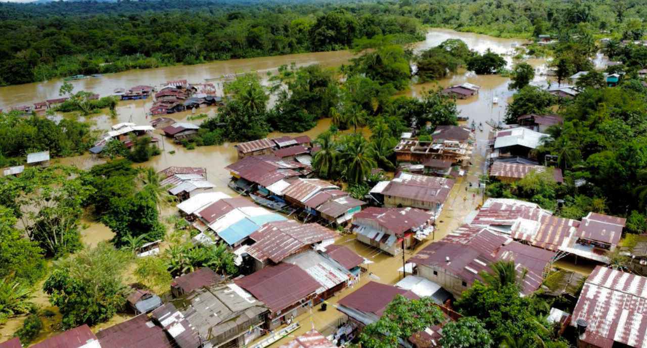
The humanitarian response following the 2023 floods in Esmeraldas, Ecuador, underscored the importance of humanitarian mapping and open data in improving informed decision-making in the region. This event marked the beginning of a long-term commitment to anticipating and mitigating extreme climate risks, such as El Niño and La Niña. Within this context, the First Ecuador National Annual Mapathon brought together 1,039 participants, who collaborated to map 15,388 buildings and 101 km of infrastructure in OSM.
Thanks to the joint efforts of the Risk Management Secretariat of Ecuador, the LAC Hub of HOT, and the Youth Mappers Geomap ESPE group, a methodology was developed and adapted for various anticipatory mapping contexts. This approach integrated key criteria to define priority areas, complementing the Secretariat’s own assessments. The methodology included:
-
Identification of areas frequently affected by natural hazards.
-
Use of Geomap-ESPE’s multi-criteria evaluation methodology, considering factors such as slopes, precipitation levels, proximity to rivers, and vegetation cover.
-
Definition of high-interest zones by authorities.
-
Prioritization of large areas requiring specific mapping strategies within limited timeframes (pre-mapping via MapSwipe).
In 2024, the Risk Management Secretariat launched the Second National Annual Mapathon to prepare for La Niña. Despite major challenges, including daily power outages caused by severe wildfires linked to climate change, more than 350 local and international contributors managed to map 26,247 buildings and 262 km of roads. This effort highlighted the resilience and commitment of the OSM community in Ecuador and strengthened the country’s disaster preparedness capacity.
The collaboration between HOT and the Risk Management Secretariat resulted in the signing of an agreement to ensure the long-term continuity of this initiative.
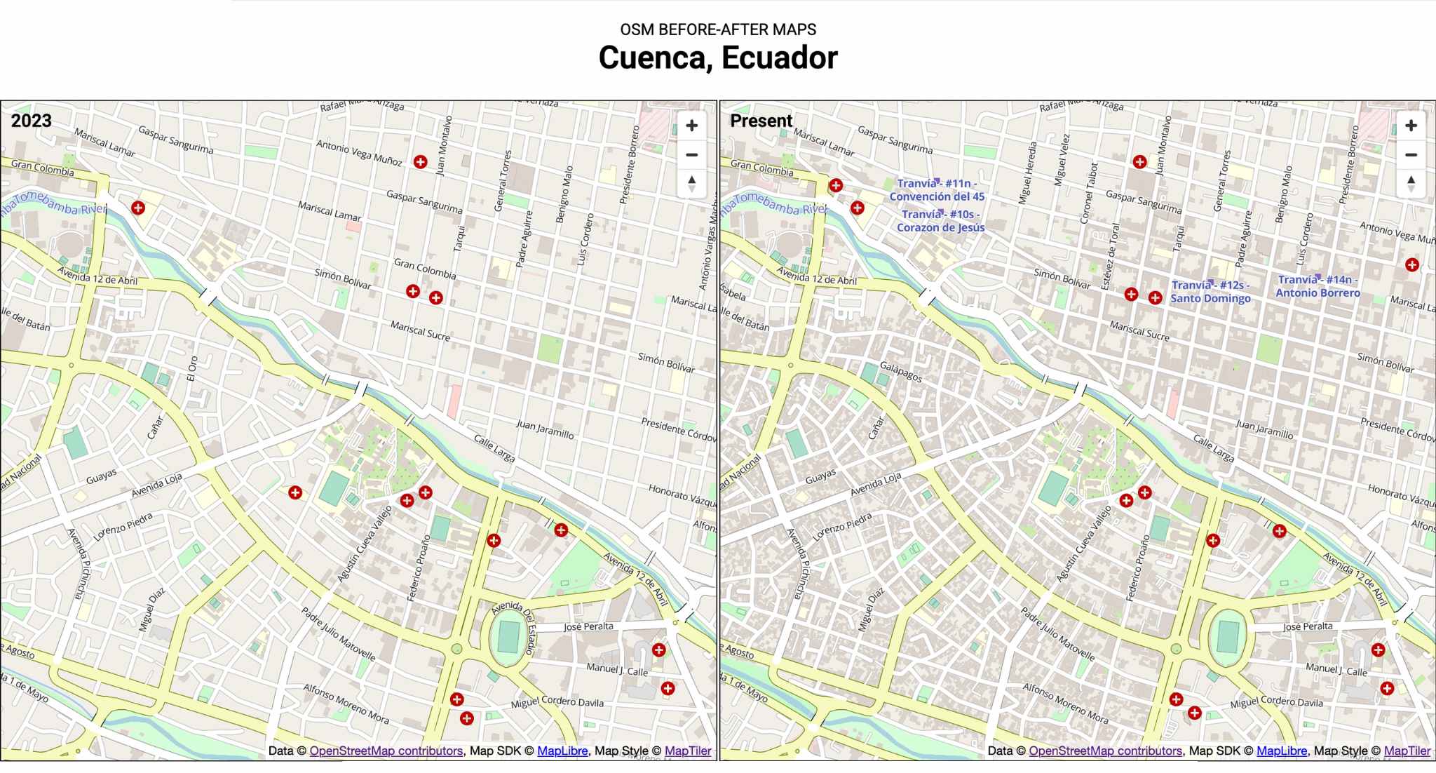
Image: Comparison of before and after mapping in Cuenca, Ecuador, carried out during the Risk Management Mapathon.
Fourth Annual National Mapathon 2024 in Peru
In 2024, Peru conducted its Fourth National Annual Mapathon, co-led for several years by the National Commission for Aerospace Research and Development (CONIDA) in collaboration with AmeriGEO. This partnership has fostered a long-term engagement through the mapathons, bringing together several ministries, such as the Ministry of Housing, Construction, and Sanitation (MVCS), the Disaster Risk Management Unit, and the Environmental Evaluation and Oversight Agency (OEFA). HOT supported this initiative by creating mapping projects and, from the fourth year onwards, by engaging in a broader mobilization of mapping communities.
In May, HOT led three virtual training workshops focused on remote mapping, introducing participants to satellite data analysis using Copernicus and OpenAerialMap. Thanks to the participation of 45 outstanding mappers, 24,131 buildings and 212 km of roads were documented in two priority areas of the Peruvian Amazon: Jaén (185,000 inhabitants) and Ciudad Constitución (5,000 inhabitants). These areas were identified by CONIDA as critical mapping gaps in need of urgent updates.
In June, as part of multisectoral collaboration, CONIDA led a three-day in-person activity within the mapathon framework, bringing together local and international actors, young developers, programmers, and remote sensing specialists. This initiative promoted innovation through Earth Observation data solutions, with multidisciplinary teams working on real-world challenges in Peru. At the end of the event, awards were given to the most innovative ideas, showcasing the potential of combining technology and local knowledge.
This fourth mapathon marked a milestone in technical capacity building and community network strengthening in Peru, laying the foundation for a more efficient and sustainable risk management approach in the future.
Video: Mapping evolution in Jaén, Peru: before-and-after comparison during the Risk Management Mapathon.
First Annual National Risk Mapathon in Colombia 2024
In September 2024, Colombia held its first National Annual Risk Mapathon during Geomatics Week, in collaboration with the National Unit for Disaster Risk Management (UNGRD) and with the endorsement of the Agustín Codazzi Geographic Institute (IGAC). Nearly 200 volunteers, both local and global, worked together to map 28 km of roads and 26,111 buildings in priority areas.
The project, developed in collaboration with local Youth Mappers groups such as SAGeMA and Tadeo Mappers, culminated in October during the International Disaster Reduction Week. This effort laid a solid foundation for expanding the initiative in 2025, underscoring the importance of multisectoral collaboration and community leadership.
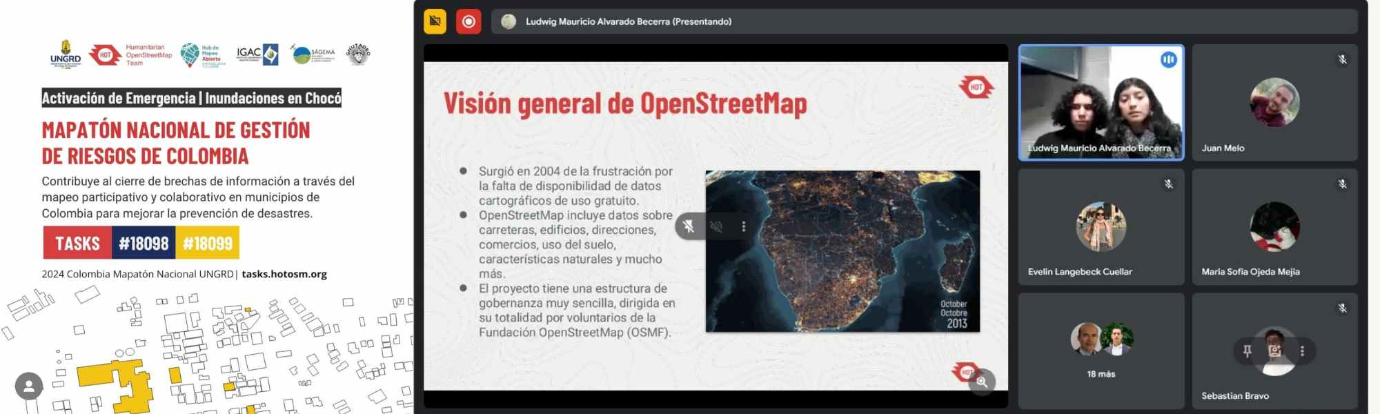
Image: Training session of the SAGeMa youth group during the National Risk Management Mapathon in Colombia.
During the mapathon, an emergency arose in Colombia due to heavy rains severely affecting the Chocó department, causing human and material losses across multiple municipalities. Given this situation, the mapathon redirected volunteer efforts to map the most affected areas requiring urgent cartographic updates. As a result, four projects were created in the Tasking Manager and successfully completed within days.
This experience demonstrated to the National Unit for Disaster Risk Management (UNGRD) the benefits of participatory mapping and the potential of an active community in generating essential cartography for emergency response and disaster risk management.
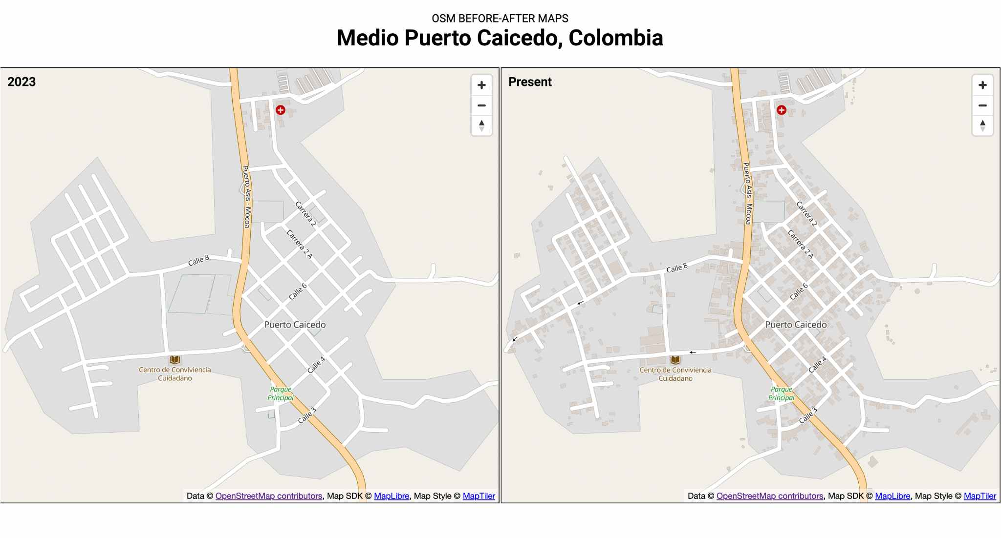
Image: Comparison of before and after mapping in Puerto Calcedo, Colombia, carried out during the Risk Management Mapathon.
Road Network Mapathon “Routes for Development”, Guatemala 2024
In 2024, Guatemala conducted its first major Rural Roads Mapathon, adapting its approach to a different context but with the same core purpose. Led by UNDP and HOT, this effort supported the planning of the new government’s flagship program, “Routes for Development”, aimed at diagnosing the condition of the country’s roads to drive infrastructure improvements and enhance rural development.
To maximize participation, volunteers were recruited through the UN Volunteers platform and direct invitations were extended to professors and students from various universities, with a special focus on campuses in the priority department of Alta Verapaz. Beyond data collection, this mapathon became a strategic opportunity to strengthen and consolidate the mapping community in Guatemala, aligning with a concrete and unifying objective for citizens.
A network of 332 volunteers mapped 50,000 roads, totaling 29,000 kilometers, highlighting 12,421 km of main roads and 17,018 km of trails and dirt roads. This project addressed decades of exclusion and tackled the disconnection of rural communities from development and well-being.
Before the project, Guatemala faced a critical gap in geospatial data on its road network, limiting decision-making processes and public investment in infrastructure. According to Juan Carlos Méndez, director of the “Routes for Development” program: “We had such a large gap that unregistered roads simply did not exist in public planning. Without precise data, we could not connect urban Guatemala with rural Guatemala, perpetuating social and economic exclusion.”
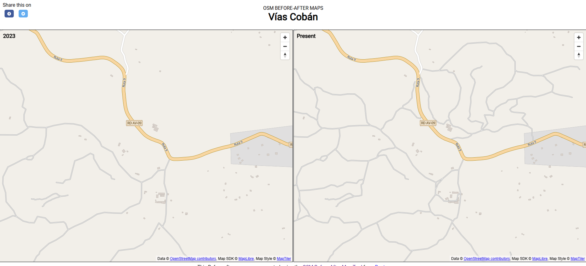
Video: Before-and-after comparison of road mapping in Cobán, Guatemala, during the *Routes for Development Mapathon.*
Before this project, Guatemala faced a critical geospatial data gap regarding its road network. This gap severely limited decision-making processes and public investment in infrastructure. According to Juan Carlos Méndez, director of the Routes for Development program: “The data gap was so vast that unregistered roads simply didn’t exist in public planning. Without accurate data, we couldn’t connect urban Guatemala with rural Guatemala, perpetuating social and economic exclusion.”
Project Stages:
-
Defining Priority Areas: Regions were selected based on criteria such as structural poverty, unmet basic needs, and climate vulnerability. The government and UNDP had already identified Alta Verapaz as a priority, followed by Quiché and Huehuetenango for these reasons.
-
Call for Participation: Given that Guatemala’s OpenStreetMap community is still growing, UNDP launched a large-scale recruitment campaign through the UN Volunteers platform, while HOT reinforced outreach efforts through direct academic contacts at various universities, particularly Universidad de San Carlos and Universidad Rafael Landívar.
-
Training: Volunteers of all ages and experience levels participated in mandatory training workshops organized by HOT, focusing on road mapping techniques.
-
Mapping: Volunteers autonomously mapped for one month, with HOT providing continuous support, answering questions, and demonstrating solutions to emerging challenges.
-
Validation: To ensure data quality, expert validators were hired to review complex strategic areas. This process was funded by HOT and UNDP, with in-kind sponsorships from companies such as TomTom and Kaart.
-
Data Delivery: The data was made available through OpenStreetMap download links and in downloadable shapefile packages, which were delivered to UNDP for government use. This ensured immediate usability by ministries while also granting access to NGOs and other stakeholders.
Key Achievements:
-
A network of 332 volunteers was mobilized.
-
50,000 roads were mapped across the country, totaling 29,000 kilometers.
-
17,018 kilometers of rural trails were identified—critical for mobility in remote areas, yet often barriers to regular communication between communities and economic centers.
-
Data was integrated into development planning programs in regions such as Huehuetenango, Quiché, and Las Verapaces.
This initiative not only expanded Guatemala’s road data but also reinforced local mapping capacities, fostering long-term sustainability.
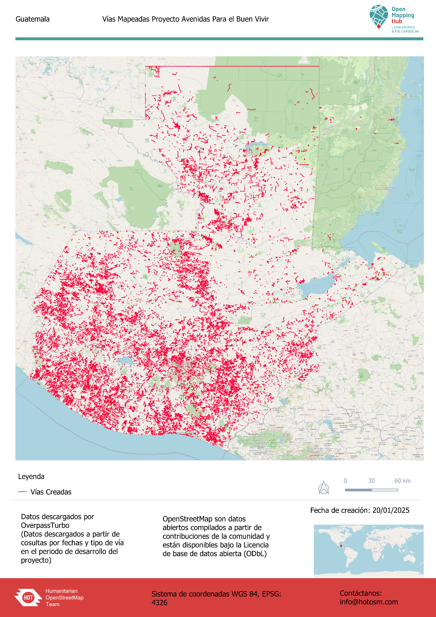
Image: Complete mapping of Guatemala’s road network as part of the *Routes for Development *update.
Where Are We Headed?
The Annual National Anticipatory Mapathons (MANA) are much more than one-time collaborative events—they are a systematic and integrative tool designed to strengthen disaster risk prevention and management. By fostering precise and up-to-date territorial knowledge through citizen empowerment, MANA ensures that decision-makers can rely on high-quality geospatial data to plan, prioritize, and allocate resources more efficiently, reaching the most vulnerable communities.
The impact of MANA extends far beyond map creation. These initiatives enhance response capacity and community resilience, playing a crucial role in evacuation planning, risk modeling, and vulnerability assessments. Additionally, the multisectoral participation of ministries, geographic institutions, and local actors has demonstrated the potential of these practices to expand and be replicated in other countries across the region and the world.
Society as a whole collaboratively produces a national map that reflects diverse voices and territorial needs. At the LAC Hub of HOT, we continue to empower youth leadership in these initiatives, as young people consistently demonstrate their commitment and ability to build a safer, more sustainable, and interconnected future through distributed effort. Programs like Open Mapping For All (OM4A) support educators and students in integrating mapping into classrooms across the region, while we maintain ongoing collaboration with youth networks such as Youth Mappers, UNDRR, and others.
For recurring initiatives like MANA, we also develop participatory mechanisms within national and local universities, ensuring their long-term sustainability and enabling them to mobilize for both their own interests and strategic needs. This approach strengthens mapping communities at the national and regional levels.
Looking ahead, our focus is on enhancing technical support, consolidating institutional partnerships, and fostering a culture of open mapping and citizen science for long-term public policy impact. This ensures the continuity and relevance of this initiative, contributing to the sustainable development and well-being of communities across Latin America and the Caribbean.
The ideal future for MANA is its full adoption by institutions and universities, embracing open mapping as a readily actionable and updatable decision-making resource. Without OpenStreetMap, generating such data would require large budgets and extended timelines, while every day without a map leaves decision-making trapped in underdevelopment and insecurity.