News — 12 December, 2012
HOT Activation, South and North Kivu, Democratic Republic of Congo
Worrying situation in the Kivus
2012-12-16 Given the more severe situation in the Kivus, HOT changes the status from Pre-Activation to Activation.
In a recent meeting, the United Nations Office for the Coordination of Humanitarian Affairs (OCHA) reported more than 910,000 displaced people in South and North Kivu in the Democratic Republic of Congo (whose about 500,000 have been displaced since April 2012). In early December, the ICRC highlighted the worrying humanitarian situation and very complex in this region. There is currently a relative lull in the areas that were hardest hit by the recent fighting, while at the same time in other parts of Kivu communities suffer the effects of fighting and acts of extreme violence, which spare neither women nor children.
The current humanitarian crisis follows decades of combats in the region. These are often accompanied by looting, arson and violence against people and provoke chronic forced displacement of population. Voir la version française de ce texte.
Coordination : Pierre Béland Contact in RDC : Claire Halleux
There are 31 camps in the region with more then 100,000 refugees dispersed in this immense territory. Refugee camps are spread around Lac Kivu, west of the lake and as far as 150 km north of Lac Kivu. Recent fights and violences against civilians provoked new displacement of populations which make difficult to evaluate the situation.
This raises the concern of humanitarian NGO’s and UN denounces the many and various forms of violence committed against civilians, including children.
For its part, the World Health Organization (WHO) estimates that “new waves of violence threaten access to primary and secondary health care for people injured in the town of Goma and in the provinces of North Kivu and South Kivu. “ WHO is particularly concerned about more rapid progression of the cholera epidemic in North Kivu, where since January 6830 cases with 65 deaths were recorded.
The protection of civilians and the distribution of humanitarian aid are priorities, but insecurity and poor roads make it difficult to provide assistance to affected communities.
According to OCHA, more than 47,000 IDPs arrived in and around the cities of Minova in Kalehe in South Kivu, and Bweremana border between South and North Kivu in the recent weeks. UNHCR and its partners have received information about tragic incidents of violence against civils.
Under these conditions, humanitarian assistance should be organized and move quickly.
HOT Pre-Activation for Lac Kivu
See the Kivu Wiki Coordination Page
While insecurity and violence continues, the humanitarian organizations try to join refugees where they are and support them. Taking into account the number of refugees, their needs for food, water and medical treatments and secure environment, plus the difficulty to locate and join them, this is a major operation.
Detailed maps of these areas are needed by the humanitarian organizations. To plan the mapping operation, the HOT team is in contact with international organizations, some NGO’S and a GIS partner on the ground.
In a context of humanitarian relief, the capacity to access rapidly to geospatial data and make analysis, is an important aspect. A great advantage of OSM data is that it is Open Data (licence Odbl). This gives to UN agencies and humanitarian NGO’s the capacity to extract it rapidly, combine it with humanitarian data layers and make the appropriate geospatial analysis. GIS tools such as QGIS and ArcGIS have the capacity to import OSM data and make the appropriate analysis.
We have identified priority mapping areas for the ungoing humanitarian effort and looked at the imagery available. Our first action is to trace all the area on west side of the Kivu lake along the RN2 road from Goma, north of the lake to Bukavu on south of the lake. This is an approximate distance of 130 km. Re-evaluation will also be made as the situation evolves in the next weeks.
Part of the region around Lac Kivu has a good coverage with Bing Imagery. To map these areas, the HOT Task Manager is used to define micro-tasks. This coordination mapping tool facilitates the distribution of task among many mappers working simultaneously in the area and assure rapid progress of mapping. Other mappers are revising mapping to assure quality of mapping.
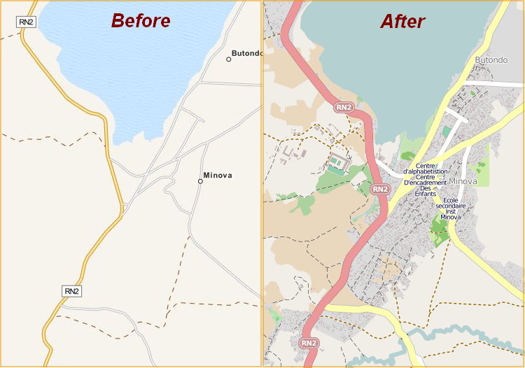
 Quick response in Minova : Four days of mapping
The first task was started a week ago for the Goma area and is now completed. This do not cover the Muganga camp eest of the city where no imagery is presently available. The tasks for Bweremana and Minova are almost completed and other tasks are ungoing for Bukavu an other areas. We are also looking at informations and support from people having a local knowledge of the region to complete the map with POI’s describing the facilities such as schools and health centers and add street names.
In parallel, discussions are made with international agencies and humanitarian NGO’s to support request to obtain imagery from spatial agencies for humanitarian reasons.


