Morocco Earthquake: OpenStreetMap data in support of response efforts
In the early hours of the Morocco Earthquake, the Humanitarian OpenStreetMap Team (HOT) and its regional Open Mapping Hub in West and Northern Africa (WNAH) identified urgent mapping needs and mobilized OpenStreetMap (OSM) contributors around the world to crowdsource information in the impacted area. WNAH and the local OSM community in Morocco coordinated the mapping efforts, directing volunteers to map priority areas alongside other stakeholders.
Background
The 2023 Moroccan earthquake struck several Moroccan cities on the night of September 08 to 09, 2023, at 23:11 (local time). With a magnitude of 6.8 and a deep focus of 18.5 kilometers, according to the USGS, the quake was followed by an aftershock of 4.9 magnitude 19 minutes later. It is now estimated that nearly 2,946 people died and 5,700 more injured as a result of this devastating earthquake. Numerous infrastructures, including houses, hospitals, and educational facilities, were destroyed, leaving many families displaced and disrupting access to basic amenities.
Natural disasters are complex events that require data to support responders effectively. Amid this tragedy, from which the country is still recovering, crowdsourcing efforts leveraging OpenStreetMap (OSM) have again proven the importance of open mapping and data in disaster response. The value of OSM as an open-data platform for disaster management was first demonstrated in Haiti in 2010. Since then, it has supported disaster and resiliency efforts around the world.
Disaster Response Effort
During a crisis, responders must quickly determine where the event happened, who is affected, and what urgent needs arise. Basic information about affected areas and populations often conveyed through maps, is crucial for effective intervention. However, not all communities are fully mapped, and disasters can quickly change mapped areas.
In the early hours of the Morocco Earthquake, HOT and the WNAH identified urgent mapping needs and mobilized OSM contributors around the world to fill data gaps to support effective response. WNAH and the local OSM community in Morocco coordinated the mapping efforts, directing volunteers to map priority areas alongside other stakeholders through HOT’s Tasking Manager. The Tasking Manager (TM) is a campaign tool specifically developed for the coordination of volunteers during collaborative mapping. A total of 5 Tasking Manager projects to map building footprints and roads made up the mapping activities.
Open Data for Disaster Response: Supporting Responders through Crowdsourcing Mapping Efforts
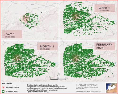
Within 48 hours of mapping activities, 310 contributors around the world had contributed 32,450 buildings and 530 km of roads to OSM using pre-disaster imagery, providing the necessary base map to support decision-making. The outcome is a detailed base map of Morocco and data on road damages aimed at providing operationally useful data.
 These maps show the evolution of OSM buildings mapped on day one of the earthquake and their increasing coverage after the WNAH started their campaign with global volunteers. OSM building data for Morocco is open and accessible on HOT’s Humanitarian Data Exchange Page.
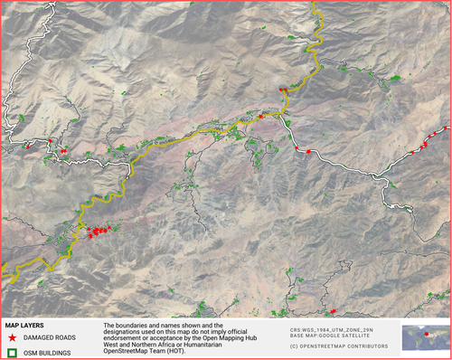
The detailed dataset of damaged roads, created by OSM volunteers during the response phase, was able to support the ground effort. Source data for the mapping was provided by MAXAR through their Open Data Program. Additional support for the road mapping was provided by Digital Egypt, to ensure data quality.
 Map showing the location of buildings and damaged roads, which were useful for other humanitarian organizations providing support on the ground.
The OSM data proved immensely valuable for World Central Kitchen (WCK), an organization that provides food for communities facing disaster. The data was very useful for locating small towns and villages, planning routes, and even estimating travel times based on vehicles and road conditions.
"Many of the hardest hit places were small villages in the mountains, not always reflected on other maps, so OSM was critical to understand smaller populated places and to be able to map places in various languages to engage both international and local team members." Ali Sharman, Mapping Specialist, World Central Kitchen.
Local Knowledge, Better Maps
The growth and mobilization of the local community are highly important for sustainable and quality response efforts. Communities are the most important stakeholders as they bring in local knowledge, which is very valuable in mapping. Apart from serving as an important indicator for assessing quality mapping in OSM, maps created with local knowledge can also enhance the delivery of effective aid.
To strengthen the capacity of the local communities in Morocco to contribute to disaster mapping and use open data for their needs, the WNAH is currently collaborating with the local OSM community leads. This collaborative effort aims to provide training on open mapping tools to professionals and students in the North Africa region.
In conclusion, OSM is strong because of its collaborative ecosystem. Strengthening efforts to create pre-disaster base data layers will enhance the speed of damage mapping. This not only supports response efforts but also provides valuable data immediately. Forward-thinking funders and aid agencies can make a significant impact by investing in disaster preparedness and response approaches. This includes supporting the technology needed to make OSM even more operationally useful, such as high-resolution imagery from satellites or drones, which can significantly enhance the quality of data available in the OSM database.
Looking for more information?
The WNA Hub has released a comprehensive report covering the outcomes of this disaster response, with more detailed information on the available datasets: Read here.
Cover image: Morocco before the Earthquake by richard evea, CC BY-SA 2.0.


