The state of HOT open mapping tech
Publié par Sam Woodcock, Raiza Pilatowsky Gruner • 23 avril 2026
[Note: this blog is a rewritten version of Sam’s original piece, published here]
Let’s be honest. How often, when we hear the words “geospatial technology,” do we picture young women from Ghana, Mozambique, or Haiti using popular messaging apps to locate trash and pick it up as part of a global UN campaign? Or residents from Sierra Leone’s informal settlements using aerial images (which they gathered themselves by flying drones!) to identify their homes and use the resulting information to improve service delivery and accessibility? Or what about people from all over Latin America digitally mapping buildings and roads in the most vulnerable areas so disaster preparedness agencies have the most updated data on who lives there?
Well, at HOT, we know that for most people, the answer is “not that often.” But as the examples above show, diverse communities around the world are using geospatial tools to address their most pressing needs. As the catalysts for those tools, we have focused (and continue to) on developing them based on the principles of inclusiveness, equity, and collaboration. Over the last couple of years, we have also incorporated another big element: interconnectedness.
Our aim is that anyone, but especially people living in vulnerable areas, can follow through the whole process of data creation/collection, access, and analysis through our user-friendly technological workflow. For each part of the workflow, we have a different set of tools:
- Imagery collection: Drone Tasking Manager and OpenAerialMap
- Remote mapping: Tasking Manager and fAIr
- Field tagging: Field Tasking Manager and ChatMap
- Data insights: Export Tool and HOT’s uMap
And for each of these, we got some exciting updates!
Imagery Collection
Drone Tasking Manager (DroneTM)
DroneTM is a widely used platform for planning, uploading, and processing drone imagery in real-world mapping campaigns. This tool has been a crucial component of different projects, such as identifying volcano escape routes in Bali and the Know Your City project in Freetown, Sierra Leone and Lusaka City, Zambia. A major goal has been improvements to imagery upload and processing: faster uploads, fewer failures, resumable, and no requirement to divide images into task areas before uploading.
OpenAerialMap (OAM)
Now that we have our imagery, where can we store it? Could it be available to more people? OAM is for that! We are talking about an open platform for sharing and accessing freely licensed aerial and satellite imagery, making it available for humanitarian response, disaster mapping, and development work.
At the end of 2025, a new STAC-based* API was released for developers and power users wishing to get an early start on usage. Going forward, we will work on a new imagery uploader in 2026, in addition to implementing a new UI to easily visualize available imagery.
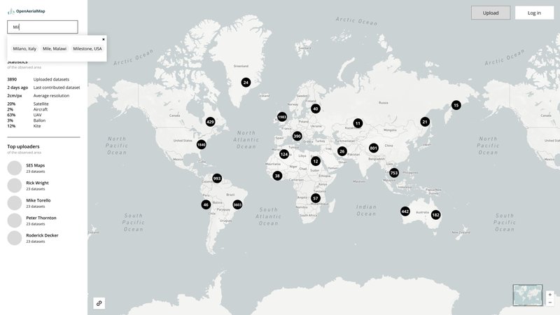
Proposed prototype for OpenAerialMap
*STAC is an interoperable standard that will facilitate serving a much larger catalog of open imagery, with richer metadata information, and potential for federation (self-hosted imagery from a government, university, or individual can all be incorporated into the larger catalog).
Remote Mapping
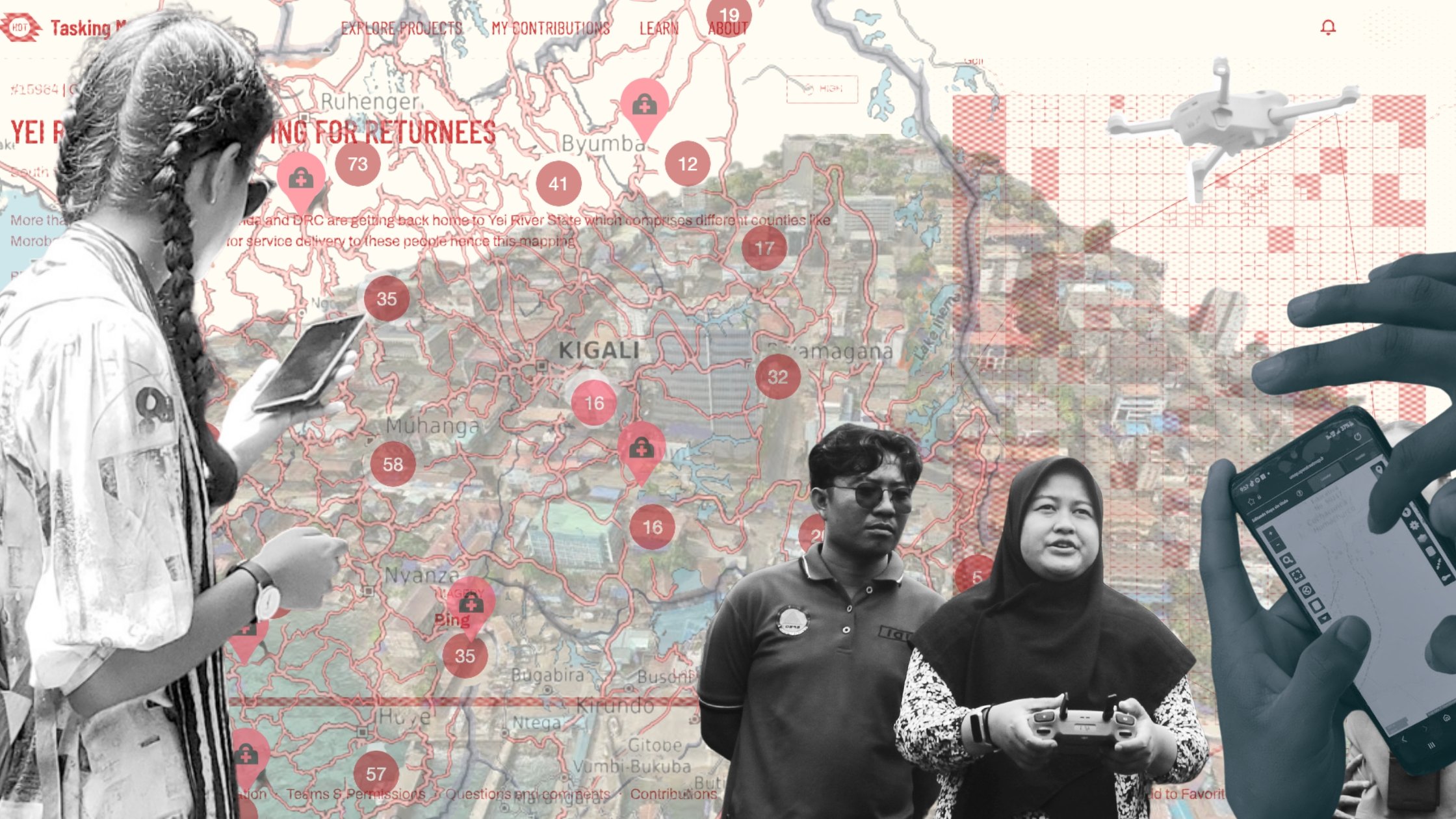
Tasking Manager (TM)
The TM is one of our fundamental tools (it has been around since 2010!), and facilitates crowdsourced remote mapping campaigns. In 2025, we worked on a significant upgrade to improve performance and stability, and to future-proof the tool. The primary goal has been to freeze TM's current capabilities and ensure the platform's stability as it is now. We have also added Super Mapper badge capability, and in February, we launched the OSM Sandbox, which lets users practice or capture mapping data without uploading anything to OpenStreetMap, opening opportunities to create sensitive or private datasets.
fAIr
While fAIr, our AI-assisted mapping tool, has had many improvements and model iterations over the years, a major shift in its approach is underway. Instead of HOT being primarily an AI-model generator, we will host fAIr as a platform to connect the geoAI developer/engineer community with the humanitarian open mapping community. The goal is for the second group to use open GeoAI models without the need for technical or programming skills.
We have also finalized work on fAIrSwipe, which lets users validate fAIr-generated features and push them to OpenStreetMap using another amazing tool: MapSwipe.
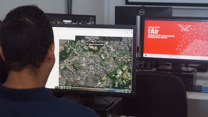
Participant of our Map2Mitigate project in Brazil during a fAIr training activity.
Field Tasking Manager (FieldTM)
FieldTM has continually morphed in different directions since its prototyping in late 2023.
After many rounds of user feedback and continual iteration, we have settled on a simpler approach to field mapping. Its primary focus will be as a project creator in downstream field-mapping tools (mainly, QField and ODK Collect), where FieldTM will be used to divide the area of interest, but task assignment and progress tracking will be handled in ODK or QField.
Stay tuned for a major update in the coming months that will bring a simpler user interface and user experience.
“Field mapping is a tricky business. There are some great tools out there that try to strip away the complexity involved, such as StreetComplete and ChatMap. The new version of FieldTM tries to make it as easy as possible to create a coordinated mapping campaign at scale, involving 10's to 100's of mappers. Allowing you to load in any collected drone imagery, and choose your preferred tool for the field mapping (currently ODK & QField). We are just at the tip of the iceberg, and I'm excited to try new approaches such as field deployments on Raspberry PI computers, and other ideas we have had over time.” -Sam Woodcock, Product Owner
ChatMap
ChatMap is a tool that converts instant messaging chats into maps. Since its inception last year, it has gone from success to success, culminating in a very effective response to Hurricane Melissa in 2025. At the beginning of this year, we launched a new design that includes a function to display live map updates as users send messages in the field, as in this campaign to monitor wildfires in Querétaro, Mexico.
Our plans for this year include integration with other tools (e.g., ESRI), shared HOTOSM user accounts, new filtering options, and a feature to save maps directly in ChatMap.
“As the community of ChatMappers is growing, it is also growing connections between people. I’m sure that networks of mappers with a common cause can emerge, with chat groups in different countries working together, similar to what happened during the World Cleanup Day 2025 but self-organized by the same community and over a longer period of time.” -Emilio Mariscal, Product Owner
Data Insights
Export Tool
Sometimes, no news is good news. The Export Tool, which provides easy access to and downloading of OpenStreetMap data, is currently in a feature freeze with no active development. The website is still available and functional for those wishing to export OSM data. A review is being made of the underlying OSM data export capabilities, and whether the tool could be simplified to ensure its longevity.
HOT’s uMap
A tool for geospatial data visualization and analysis, HOT’s uMap has seen 11k visitors and 592 maps have been created just in the first quarter of this year. Our next steps include improving its UI/UX and its integration with ChatMap and other tools, and creating learning materials to support its users.
The Dhaka Thrive Dashboard is a centralized platform that provides visualization of hazard risks, critical lifeline facilities, and other essential information in Dhaka’s informal settlements, including street-level imagery. It equips stakeholders with the insights needed to design informed, sustainable, and resilient urban solutions.
For more details on all these tools, check this overview and the tech documentation site, including links to roadmaps.
The big reveal
Finally, we are working on a big update that connects all of the tools 🥁🥁🥁… The HOT portal! This single platform will serve as the gateway to all the above tools, providing a simpler user experience. The Portal will ensure the same login is used across all the tools: login once, access any tool. So stay tuned for more news on this big development!
Interested in this topic?
- Join the conversation on our #geospatial-tech-and-innovation Slack channel,
- Contribute through GitHub,
- Subscribe to our tech tools newsletter,
- Or reach out directly to tech-data@hotosm.org
Share
