Moving Towards a Data Resilient Caribbean: A Collective Path Forward
Posted by Arnelle Isaac • May 18, 2026
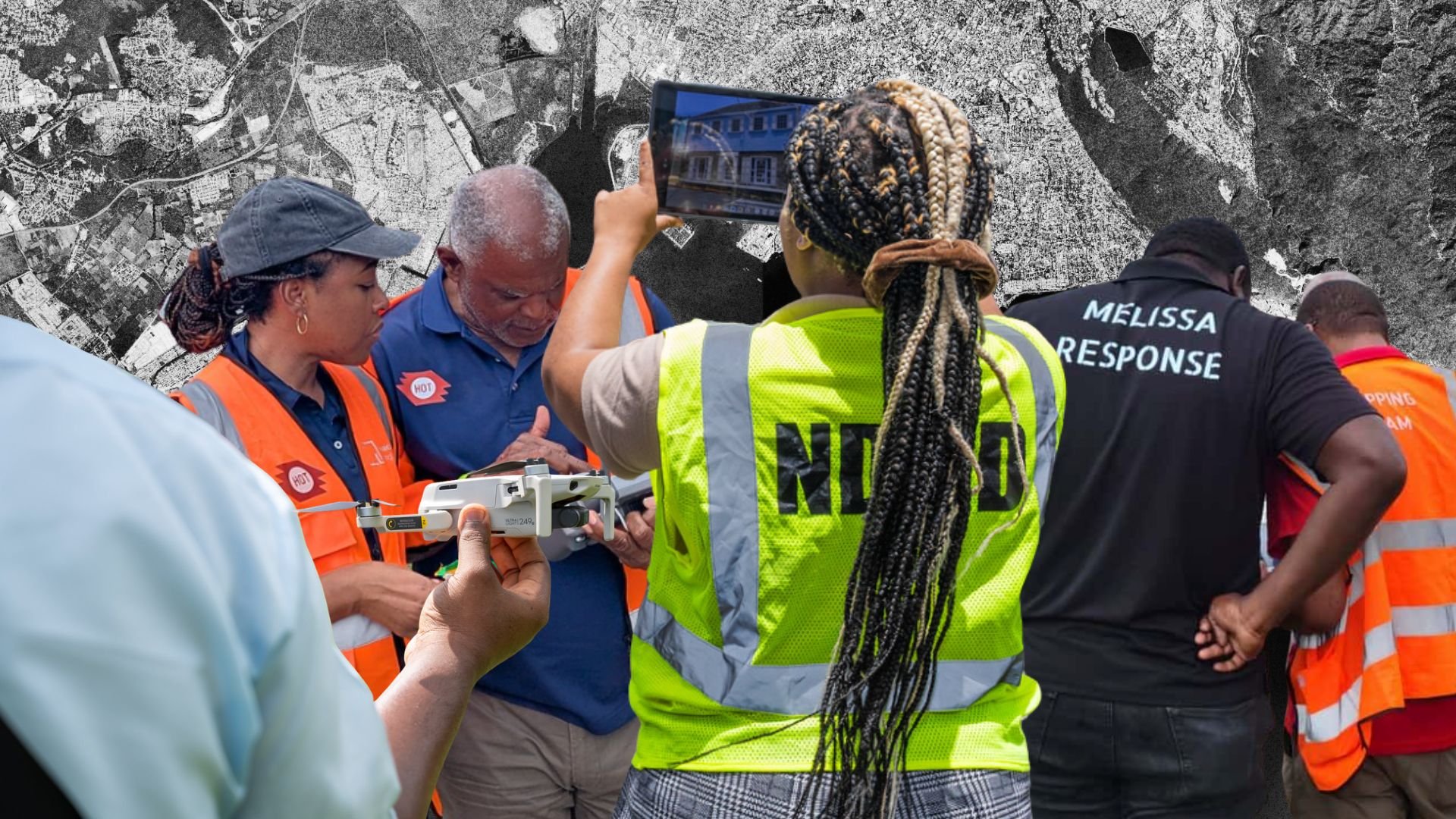
What HOT and Partners Have Been Building in the Caribbean
In 2025, HOT recognized key themes plaguing the Caribbean region through various projects and stakeholder engagements. As an organization focused on using open-sourced data for humanitarian action and development, HOT has implemented many projects throughout the Caribbean region that seek to fill these gaps.
For example, the Emergency Resources Mapping Project in the Caribbean in Saint Kitts and Nevis sought to develop a comprehensive map and database of the emergency resources in St. Kitts and Nevis. This project was conceptualized by HOT and the Caribbean Disaster and Emergency Management Agency (CDEMA) in 2023 to support CDEMA's Participating States with data-driven decision making. By using open source tools to collect critical data on various existing resources that exist for emergency management, Saint Kitts and Nevis' national disaster offices were equipped with easily accessible and critical data. Key stakeholders including government officials and volunteers were thoroughly trained in open source data collection and analysis and mapping methodologies which is critical to sustainability.
Video showcasing the Emergency Resources Mapping Project in St. Kitts and Nevis through open data and community-based mapping. Led by HOT in collaboration with CDEMA and local agencies, the project maps critical resources like shelters, clinics, and key infrastructure to support more effective emergency response and resilience.
The Youth Champions in Emergency Mapping (YCEM) Project trained youth in Grenada, Dominica, and Saint Lucia, members of the Youth Emergency Action Committees (YEAC) and the Dominica Red Cross, in open-source data collection, analysis and mapping tools. As first responders in their communities, these volunteers are essential to strengthening data systems at the local level.
HOT also awarded community microgrants to organizations in Haiti, Grenada, Saint Lucia, and Trinidad and Tobago, combining remote, field, and drone mapping to build climate resilience and disaster preparedness. Each project was locally designed to tackle community-specific challenges:
- Haiti: Mapping of schools and high-risk areas to support displaced populations, providing data to the municipality and advocating for safety signage.
- Saint Lucia: Beach clean-ups led by the YEAC, paired with mapping and reporting on coastal litter.
- Grenada: A youth-led Tsunami Response plan, including updating the digital map and presenting findings to emergency response agencies.
- Trinidad: The GIS Society of Trinidad and Tobago (GISSTT), alongside the Office of Disaster Preparedness and Management (ODPM), delivered a five-module drone training program and produced a foundational dataset of a coastal zone prone to storm surges and erosion.
Overall, these initiatives and activities have proven impactful, with approximately 107 persons trained in open data concepts across the region. Yet they also revealed the depth of the structural challenges that remain: no single project, however well-designed, is enough on its own.
Bringing Partners Together: The Jamaica Workshop
A recap of the regional workshop held in Kingston, Jamaica (August 12–14, 2025), where HOT and the Caribbean School of Data convened more than 30 community leaders, government officials, donors, and mappers to explore how open data and community-centered mapping can strengthen disaster preparedness and response across the Caribbean.
To discuss this further and to understand HOT's role in providing solutions for these challenges, HOT organized a regional workshop in Jamaica in August 2025. From August 12–14, 2025, in partnership with the Caribbean School of Data, HOT hosted a workshop in Kingston, Jamaica, where partners from different sectors convened to collectively imagine the future of the geospatial sector in the disaster management world. For two and a half days, more than 30 community activists, government officials, intergovernmental organizations, donors and mappers envisioned different ways in which, at this critical juncture, greater collaboration can enable a new way to address the specific challenges which the region faces.
Several key themes emerged from the conversations:
Start with data
Without adequate data, it is extremely difficult to prepare, respond or rebuild after a disaster. While the open data agenda made some inroads in the region, capacity and access to use it remains low. Data sources remain fragmented, expensive, and governments have little capacity to access, pay for and effectively use them. Open data, such as that provided by OpenStreetMap, is a solution to these problems. The open map can also be updated more regularly and efficiently than other sources, providing good quality and relevant data for the purpose at hand. The development of open source solutions allows for more customizable and less expensive tools that everyone can use, and has relatively low barriers. Take for instance the work HOT implemented in Dominica, Jamaica and St Lucia with the Drone Tasking Manager. This project enabled several communities to collect high quality data with drones, which can be used in planning and response efforts, while also supporting the creation of work competencies in the region. Yet this is just one project; thus, adoption, expansion and support for this platform would mean reaching out to more users and getting better imagery.

Data and tech alone will not be enough
Data and tech need to be properly collected and analyzed by people trained to do this. Open training ensures that competencies are developed in the region, such is the work the Caribbean School of Data and other groups have been doing. And yet more needs to be done to make sure training reaches different levels of government and community groups.
At the core of these efforts are different community groups. They are at the forefront of the efforts to plan and eventually respond to incidents, but when they collect data they do so much more than this. They create awareness about the potential challenges, they engage with residents distributing information and they are already embedded in the communities when the disaster hits. If more community groups are incentivized to collect and use data, governments would also have significantly better and updated information, and also the connections to engage communities when it is required.

Coordination still demands significant efforts in the Caribbean
Regional bodies like CDEMA and OECS are essential to advance collaboration efforts, but such work needs significant investment and coordination over time. The idea that a shared data infrastructure is needed should be advanced by a multi-stakeholder group, so it could serve the very different needs of the Caribbean.

Where We Go From Here
All in all, we left this workshop grateful and humbled by the partnership offered by all of our colleagues. In the next months, we will be working towards three objectives:
- We aim to support a multi-stakeholder group that advocates and advances the use of open community generated data in the region, starting with the partners convened in Jamaica, and serving the diverse needs the Caribbean has.
- In partnership with our colleagues, we aim to advance the case of a shared infrastructure, a "data commons" that could be used to collect and scale the use of data across the region.
- Finally, you will also see us working on improving the ways in which we can scale training and capacity building on data collection and data use, building on the community-level work already underway in Haiti, Grenada, Saint Lucia, Trinidad and Tobago, Dominica, and Saint Kitts and Nevis, so that community groups can be empowered to sustain their work on the ground.
We want to advance a data resilient Caribbean, where communities are at the centre of data generation and data use. We are not going to do it on our own, but with a group of committed partners. We will not be able to do it all, but we invite others to join us while we do our part.
Share
