News — 09 March, 2023
Turkey And Syria Response: A Month After The Earthquake
The mapping response to the Turkey and Syria earthquake has shown the power of OSM data to support disaster response.
Maps are fundamental to the work of disaster response. They show where households at risk are, where essential services like hospitals are, and how responders can reach affected communities.
But not every community in the world is mapped, and disasters like floods and earthquakes can radically alter the terrain that is mapped in a moment. Mappers came together after the devastating 2010 earthquake in Haiti to use satellite imagery to make maps on OpenStreetMap (OSM) that aided the response effort.
The community that arose from that tragic event has stayed together, and OSM is again serving as an invaluable platform for lifesaving geodata in the aftermath of the Syria-Turkey earthquake of February 2023.
Much of this data is the result of a huge solidarity effort from thousands of OpenStreetMap contributors in both the affected countries and around the world. In a humanitarian response such as this, it is hard for a member of the public to contribute beyond making a financial donation, but data generated by mappers is already in the hands of responders and has an impact on the ground.
Road Networks
Earthquakes create extreme challenges for navigation. Internet and cellular networks are damaged or overloaded, and damage to roads and bridges means navigation data from before the quake are suddenly inaccurate. For Ankara surgeon Dr. Çevik working to save lives in communities damaged by the earthquake in the Hattay region, Organic Maps and the OSM data that feeds it were essential for him and his colleagues to get to the people that needed medical attention.

Message from a doctor in the field to a mapper. Translation: On the first day I went to Rehaniya, when google maps was not working, Organic Maps guided us. The importance of such tools is enormous. Good luck to you, Can. 🔥 organic maps 🔥
Critical Infrastructure
Beyond road networks, information on OSM about critical infrastructure, such as hospitals, pharmacies, food depots, transportation nodes, and settlements, is playing an important role in providing organizations like the World Food Programme key insights into field conditions, both pre-and post-earthquake, for logistics planning. Without this data, planning the movement of goods, resources, and personnel efficiently in the aftermath of an earthquake of this magnitude would be much more challenging.
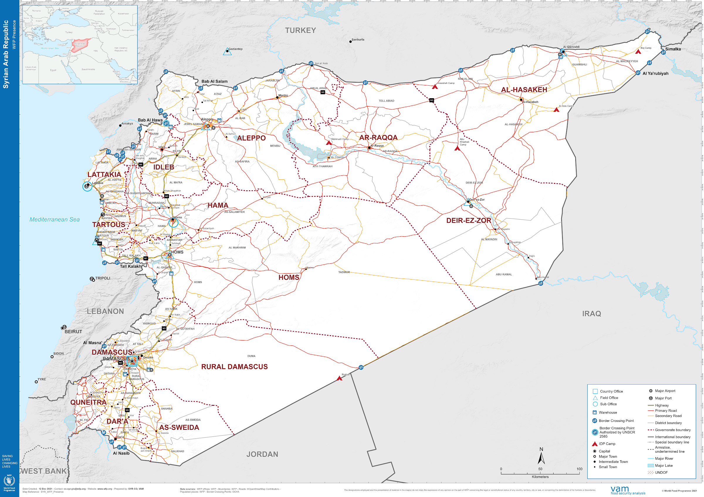
World Food Programme map depicting access routes and other key logistical pieces in the affected areas. Use of OSM roads credited.
Base Maps
OSM enables the rapid creation of maps in areas that did not have pre-existing map data. In the aftermath of this earthquake, the capacity for real-time updates and open access meant that aid agencies Search and Rescue Association (AKUT)and Republic of Türkiye Ministry of Interior Disaster and Emergency Management Authority (AFAD) were able to use OSM data in their maps to coordinate and ensure that logistics resources were used efficiently. In a scenario such as this, knowledge of the built environment enables better decisions for reaching people in need and understanding people’s requirements and what infrastructure exists locally.

"Wonder if your contributions help the rescue teams? We heard back from AKUT and AFAD coordination officers and wanted to pass their messages. 'Thanks for mapping affected areas to support our rescue coordination, infinite thanks!'" Tweet from Yer Cizenler on February 13th 2023
Imagery and Building Damage
Promptly after the earthquake hit, organizations like the International Federation of the Red Cross/Red Crescent (IFRC) requested building-level vector data for post-disaster damage assessments from Yer Cizenler, the coordinator of the response. Using government data, a Copernicus damage analysis, and pre-disaster OSM building footprints (more than 1.6 million have been mapped through today via the HOT Tasking Manager), IFRC performed a geospatial analysis to help them plan their aid in relief and recovery efforts by pinpointing the exact location of each destroyed building.
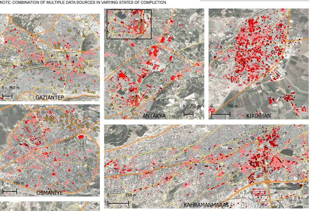
"South-East Turkiye Earthquake: Building damage composite of available sources for highlighted cities" using OSM/HOT data February 16 2023.
With the intent of increasing the availability of damaged building data and properly reflecting the current state of the conditions in the ground in OSM, Yer Cizenler also used the Copernicus damage analysis to update OSM buildings through a MapRoulette campaign. The validation process involved high-resolution imagery from drones and satellites, which helped ensure the quality of the digitized data. The resulting dataset that identifies destroyed buildings is now available through HDX and has been downloaded over 500+ times.
The Data Needs Will Evolve
In addition to the above, and as the phases of the response shift, OSM data will also be used for long-term recovery efforts, such as rebuilding infrastructure and housing and improving disaster preparedness. The availability of detailed, up-to-date map data is an important resource in all stages of the disaster recovery process.
It is important to remember that behind each data point, there is a tremendous human effort from volunteers and organizations. Every single object that has been mapped so far, has had human eyes creating, modifying, or validating it. The effort continues and, if you are a mapper who wants to get involved, you can do so here.
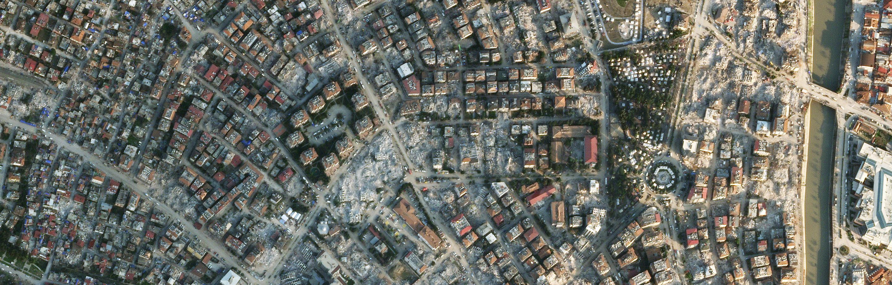
Lead photo courtesy of Planet, date 20230211