News — 22 June, 2012
Finishing off the refugee camp mapping
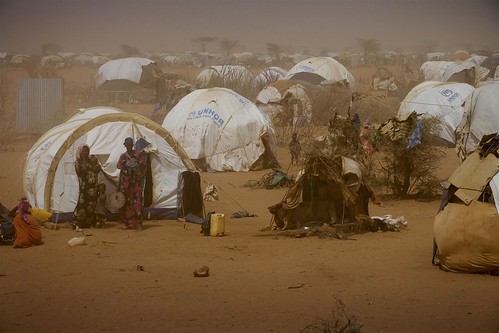
Last month we asked people to help map refugee camps in Kenya and Ethiopia.It was an excercise in coordination using the HOT Tasking Manager, but this was initially also an experiment testing out various workflows and organisational interactions as part of a "Camp Roberts" excercise for the acquisition and setting up of imagery. We were working with the U.S. State Department and U.S. Agency for International Development using special aerial imagery from NextView. They wanted to see how, given this imagery to trace from, our community could map the refugee camps in a short space of time.
Last month we asked people to help map refugee camps in Kenya and Ethiopia.
It was an excercise in coordination using the HOT Tasking Manager, but this was initially also an experiment testing out various workflows and organisational interactions as part of a "Camp Roberts" excercise for the acquisition and setting up of imagery. We were working with the U.S. State Department and U.S. Agency for International Development using special aerial imagery from NextView. They wanted to see how, given this imagery to trace from, our community could map the refugee camps in a short space of time.
And we didn't disappoint! Josh Campbell wrote up some results and thanked the "OSM volunteers who donated their time and energy to mapping these camps – you literally helped put 600,000 people on the map"
But actually we're not quite there yet. Intially a timeframe of 48 hours was mentioned, and we did acheive a great deal within those 48 hours last month, but come the deadline we were still busy and still making great progress, so they thought why bring it to an end? In fact the imagery has remained available. Maybe this wasn't clear, but you're still very welcome to dive in and help.
So let's have a final push to fill in all those Task Manager squares!
At time of writing some of the jobs are complete (a full grid of red task squares). The majority of remaining tasks are to be found on the original IFO camp job. There's a few left on others lower down the list.
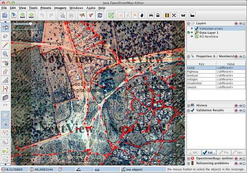
This mapping has brought up some questions and ongoing discussion on the HOT mailing list. With many different people getting involved in mapping in little square areas, some of the tagging inconsistencies of OpenStreetMap are brought to the fore. Some general advice:
- Be bold. Be bold in trying out mapping if you haven't tried it before. We'd love to welcome you to the mapping community. If you make mistakes, others will help correct them.
- The above point works better if we also try to be bold in correcting eachother's work. With a bit of mapping experience under your belt, that makes you an expert! The data is not "owned" by the person who added it, so don't be too timid about fixing stuff which looks wrong.
- Go for consistency. Tags can be difficult and open to judgement and interpretation, particularly when it comes to classifying roads and footpaths seen in aerial imagery. For a small footpath, there's a question of whether to map it at all. By no means obvious. There's discussions on the mailing list which you can join in with, but actually the most helpful approach might be to pan around the whole area, see the data added by other mappers, see how it renders, and aim to be consistent.
- But finally let me say it again. Be bold!
OpenStreetMap keeps a full history of who's contributed and when. This rich meta-data should make for some interesting analaysis. Will your username be on the list of contributors? Let's get those refugee camps mapped!